The need to get away from work coupled with a desire to re-visit the Welsh coast resulted in a much a weekend break in mid-Wales, or more precisely, to coastal location which was also close to the Ynys-hir nature reserve and to a Red Kite feeding centre, aka BBC Springwatch and Countryfile respectively! We chose Aberaeron as our base, a pretty Georgian coastal town, and apparently one of Wales's first planned towns. We were not disappointed.
Sixteen miles south of our destination we stopped off at the well known town of Aberystwyth, which had all the pre-requisites for a UK seaside town. A Victorian pier, bustling promenade, sandy beach and impressive row of pretty pastel hotels all formed part of the gently sweeping curve of the bay, which was itself flanked by Castle ruins at one end and a grassy headland at the other. And somewhere in the middle was 'The Olive Branch', offering not just peace, but also food! Once fed and watered, we spent an hour or so exploring what Aberystwyth had to offer, and as usual we left clutching postcards, local maps and walks and a personal photographic representation of Aberystwyth.
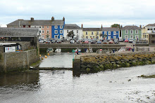
By the time we arrived in Aberaeron, we were keen check into our B&B, and then to check out whether this little town and harbour lived up to the stunning photographs on the website. The only marketing misconstruction was that the sky above the harbour is not always blue! But as if to make up for this, the colour of just about every building in Aberaeron is as pretty as a paintbox of pastel watercolours. We wandered around the harbour familiarising ourselves with our new home for the weekend, before embarking our first walk, one which traced the meandering River Aeron inland, along ancient tracks, sometimes edged with woodland, or hedgerow, but always with a feeling of being at one with nature. Some 2 hours later, the harbour welcomed us back with a silver sunset.
The next morning we were ready for a hearty breakfast, so stocked up on carbohydrates for the day ahead. A full 'Welsh' breakfast, cereal, dried fruits, yoghurt, toast and marmalade, and every variation of tea known to man (or at least to Linda the landlady) was on offer. We set off down the coast with a list of pre-researched places to visit, and the first stop was at Cymtydu. Difficult to pronounce, but easy to love. Cymtydu Cove was virtually uninhabited, no buildings, no cars, no people, just nature. Unfortunately nature was doing its best to hide the charms of this place by shrouding it in a cloak of mist. But we rose above this, literally, as we climbed away from the beach up and round the headland on the coastal path. Our plan to follow Walk No 8 in our book began with the best of intentions, but the weather had other plans. We cut short our walk and returned to the car, damp but no less enthusiastic about exploring this coastline.
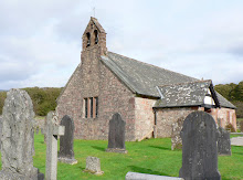
Our second stop was even shorter than the first, in fact we didn't stop until we had passed through Llangranog, a little town nestled between 2 headlands, picturesque and peaceful, but wet, so the intention was to call in on the way back. However a quick stop for a couple of backward view shots was all we were to see of Llangranog. Penbryn beach was calling, and with it our third stop and Walk No 3! We were getting a feel for the coastline by now. Small and smooth sandy coves, deep and craggy inlets, grassy headlands, thinly populated but thickly verdant, and stunning surrounding landscapes. Our walk began from the beach, wound upwards onto the headland, inwards through woodland, and upwards further across meadows until we reached a tiny little whitewashed Church on top of the hill. St Michael's Church has ancient 12th Century origins, purportedly. It even boasts a circular churchyard. We will probably remember it for the friendly curly-coated sheep who found solace and shelter in the remote church-yard and who were not afraid to be patted and photographed by passers by, possibly the first they had seen for some time! The walk back down through the wooded valley was quicker, partly due to descent being quicker than ascent, but the promise of a cafe, coffee and cake might have helped.
Our 4th stop was equally as unpronouncable and pretty as Cwmtydu. Mwnt is a National Trust treasure. Not just because of free membership car parking, but because this gem of a cove is set into a crown of soft green fields and rolling hills ... and one hill in particular which promised us our 4th walk, and the best of views across this picturesque haven of peace. The ascent up Foel y Mwnt began from another tiny whitewashed pilgrimage church, this time with origins in the 6th Century. But we bypassed the sacred for secular as we continued upwards through the brief break in the mist and murk, with the prospect of a view driving us forward. As we climbed the track steepened, and our car became a dot on the green landscape and the handful of people on the pale cream sand were specks. But as we approached the top of the hill the wind whipped up, the mist descended and the outstanding and long distance views were washed out. Once again another quick descent was called for but as we reached the bottom the sun came out once again. Fickle weather aside, it had been a fun climb and worth the damp battering for the views along the way. Taking advantage of continued sunshine we went down onto the beach and enjoyed looking at 'our' hill from a very different perspective.
Cardigan was to be our 5th and final stop of the day. We anticipated spending a couple of hours in what I presumed to be the largest town in Cardiganshire, the County town. Cardigan (or Aberteifi if you're Welsh) was indeed once a hugely influential port, located on the River Teifi estuary. The little market town and harbour is pretty enough, but after an hour we came away confident that we had seen and captured as many views and postcards of Cardigan as was necessary. No cardigans were purchased though. Contrary to popular belief (and mine) these garments were named after James Thomas Brudenell, 7th Earl of Cardigan.
With unexpected additional time on our hands we moved on southwards to Poppit Sands, mainly because it sounded like fun. Personally I would drop the 'Poppit' from the name! But we found a photogenic section of beach where barnacle covered rocks held our photographic interest for a while.
We arrived back at Aberaeron early in the evening, with appetites and anticipations high for a fish and chip supper on the harbour wall, watching the small world of Aberaeron go by, and the sun go down. Fish, chips, and sun, were met expectations and went down very well!
Sunday morning arrived far too quickly. So much still left to see and do, and so little time. Should we go to the annual Aberaeron Cob Fayre? Our landlady Linda was certainly keen that we shouldn't miss this local event, and had we been staying a week, we would have done so. The cob is a small horse, of stout build, with strong bones, large joints and a steady disposition - so a body type rather than a specific breed of horse. That aside, the call of Nature Reserves was stronger than that of Cob Horses, so we said our goodbyes to the pastel pallet town of Aberaeron and drove northwards up the coast.
En route to our first nature reserve we came across Borth, which can best be described as a linear town - strung out along the coastline with the sea in front and nothing but marshland behind. The best views of Borth and beyond were seen from a Viewpoint high above the town. In the distance, and sitting at the base of the most southerly hills of Snowdonia National Park, the Dyfi estuary flows out into the sea. The estuary forms the border between the counties of Ceredigion and Gwynedd - essentially between north and mid-Wales. It also marked the most northerly point of our visit.
Driving through the long town of Borth and out the other side, we failed to realise that its beaches held a secret only revealed by the tide. An ancient submerged forest is apparently visible at low tide along the beach, where stumps of oak, pine, birch, willow and hazel can be seen. Radiocarbon dating suggests these trees dies about 1500 BC! Radiocarbon dating suggests these trees died about 1500 BC. A missed opportunity for us, but other than sacking the researcher for this weekend, there was little we could do!
But we didn't miss the opportunity to explore the Ynyslas National Nature Reserve, just beyond Borth. The reserve was cunningly disguised as the beach, but actually comprised a mixture of peatbog, estuary and dunes which offer a rich home to feeding wading birds, wild flowers and rare orchids. Also a home to dead jellyfish and invading pirates (in the Information Centre!), and an opportunity for us to walk, explore and photograph all that his most northerly corner of Cardigan Bay had to offer.
Just 7 miles further down the road we arrived at Machynlleth, home to the Ynsy-hir Nature Reserve, and to the new BBC Springwatch site. Set amongst forest and rolling hills, edged by the now narrow and meandering River Deifi and overlooking a stunning lake, it is hardly surprising that the BBC were keen to make this the new home of Springwatch in 2011. Before embarking on one of the 4 trails around the Reserve, we were treated to an impromptu guided tour of the 'Springwatch' home, and an insight into what it was like having an 80-strong BBC production team on the Reserve for some weeks. We viewed the converted Tractor Shed cum Studio with its ecologically planted grass roof, the wooden and environmentally built patio cum broadcasting balcony, the televised compost heap and home to snakes and the swallows nest in the barn. And next Spring we will view these once again, but from a new enlightened perspective.
We decided to follow the Wetland Trail, the longest of the 4 routes around the Reserve, but the one with the best views of the estuary. The walk in itself was rewarding for the landscape, which was just as well, because other than sheep, any wildlife was hidden, even from the Hide! But once back at the Information Centre we watched chaffinches, coal tits, blue tits, greenfinches, and siskine fly back and forth to giant bird feeders as they tucked into their tasty seed. We on the other hand, sat watching them from our bench as we tucked into big buttery biscuits and massive mugs of coffee! But it was time to move on to bird feeding on an altogether larger scale.
Our final stop of the day, and of the whole weekend, was in Bwlch, at the Forestry Commission Visitor and Red kite Feeding Centre. Dinner was due to be served at 3.00 pm so a degree of planning and clock watching was required. But not so for the Red Kites! At 3.00 pm the food was distributed by the lake, over a small area no bigger than 20 feet wide. Within minutes the grey skies gradually began to fill with the familiar calls, distinctive tails, and unmistakable silhouettes of the Red Kite as they gathered in every increasing numbers, encircling, waiting, watching ... then swooping down a few at a time, taking their fill and delighting the crowd. We left the area delighted by what we'd seen, but amazed at how 60 or more Red Kites from miles around had turned up on time, en masse, and on cue for their dinner ... and not a clock in sight! Sadly their flying speed and location was too high to capture the spectacle adequately, but it was a fitting high point at which to leave Wales and head home.


