Brownseys Travelography - The Sequel

This is my second blog - a 'travelography' of some of the places to which I've taken my camera. It's the sequel, the 'overspill' blog to my first one, which I managed to fill up! If you like the way this one is shaping up then check out the original (see 'more photos')

Tuesday 9 June 2009

West Cumbria

Having enjoyed Brothers Water, the most shallow and possibly smallest and most secluded of East Cumbria's lakes, it's also been my privilege to enjoy one of West Cumbria's lakes, the deepest, darkest and perhaps most awe-inspiring of them all, Wast Water.

Tucked away on the west side of Cumbria in the Wasdale Valley, and cut off from the rest of Lakeland by its mountains, Wast Water and it's valley are little changed by human habitation or tourism. I was inspired by this place. Apparently Wainwright was too. He wrote, "one of the loveliest of Lakeland's valleys, descends from the highest and wildest mountains in the district to the sands of Ravenglass in a swift transition from grandeur to beauty ... it is a place of many delights, the finest of all valleys for those whose special joy is to travel on foot, and a paradise for artists." In sharp contrast Wordsworth rather harshly described it as 'long stern and desolate', it's true the fells can appear dark and foreboding, but then again, it has recently been winner of a TV vote to find 'Britain's Finest View'! Clearly it can't be all things to all people, but that's fine by me if it means that Wast Water remains unadulterated and uncluttered by people.

When it comes to extremes, this western region of the Lake District is purportedly home to England's deepest, coldest, highest, steepest, smallest and oldest! Scafell Pike at 978m being England's highest mountain, Wast Water at 258 feet it's deepest and coldest lake, Hardknott Pass it's steepest road, St Olaf's Church it's smallest church and Boot Mill, it's oldest working water mill.

When it comes to statistics, Wast Water is approximately 3 miles long and a third of a mile wide, and it's picturesquely hemmed in by a panorama of majestic mountains, Red Pike (802m), Kirk Fell (438m), Whin Rigg (535m), Illgill Head (609m), Great Gable (899m) and Scafell Pike (978m).

It's also one of the finest examples of a glacially 'over-deepened' valley - the surface of the lake is about 200m above sea level, while it's bottom is over 50 feet below sea level. And falling dramatically into this deep lake from a height of 610m above the surface to a depth of 61m below it are 'The Wast Water Screes'. These dramatic and foreboding sliding scree-covered slopes were formed as a result of freeze/thaw weathering erosion on the rocks that cascade down from the slopes of Illgill Head and Whin Rigg. Poetically, these have been described as 'inverted arches of Gothic cathedral'. Ecologically, they form part of the Borrowdale Volcanic Group, and are typical in formation for the south western area of the Lake District.

We didn't know all that stuff before we went, of course. I wanted to see Wast Water purely because it was recommended to me as being one of the quietest, most well hidden lakes, surrounded by some dramatic high peaks and in an area with few access roads, none of which are wide or flat. Perfect!

On the day we visited Wast Water the clouds had descended into the Wasdale Valley hiding the peaks, but revealing the awesome atmosphere of this place. A narrow road lead us around the lake's north shore leading to the valley head and to the tiny hamlet of Wasdale Head, and it was here that our walk began.

Leaving the pretty white Wasdale Valley Hotel behind us, and the imposing 'upturned-boat shaped' Yewbarrow Fell (628m) behind that, we followed the waymarked trail across the valley eastwards. With views of Scafell Pike ahead, we continued our low level walk along the path and over Lingmell Beck until we came to a tiny church nestling in the valley behind a screen of trees. We later learned that St Olaf's Church is one of the smallest in the country, and alledgedly, it's roof beams have come from Viking ships, which is feasible, given that this valley was indeed colonised by Norse farmers in the 9th and 10th century. We didn't venture inside however, as the scenery outside had a stronger attraction.

The next mile or two of the footpath was bordered by one of the many dry stoned walls that cross-cut Wasdale Valley, some forming sheep pens, others forming hump-backed bridges over the beck and many of them following the contours of the lower fell. But collectively they added focus, foreground and photographic value to this already pretty valley.

On reaching the foot of Kirk Fell, we stopped to have a quick bleat with 'Walter of Wasdale' who was busy grazing on bracken and gazing through the mist on it's slopes. Walter and his woolly mates were a bit bemused by our interest in them, but obliged us with some photos and a few baas nevertheless.

For the last section of our walk we took a detour along the lower contours of Yewbarrow Fell, arriving back at Wasdale Valley Hotel in time for rest and refreshments, before leaving this very special place. But not for the last time. We'll be returning to this dramatic and captivating place very soon!

Sunday 7 June 2009

East Cumbria

Our first weekend break together was spent in Ullswater, home to the second largest lake in the English Lake District. But with so many magnificent mountains (fells), valleys and lakes in Cumbria there is always a difficult (but delightful) choice to be made when deciding which part to visit.

In our case the choice was narrowed down by certain key criteria. It had to be a quiet and un-commercialised location, positioned fairly centrally to allow easy access to surrounding areas, with outstanding natural landscape all around and with a choice of walks on the doorstep. As the last two criteria are pretty much a given anywhere in Cumbria, we just wanted somewhere peaceful and picturesque!

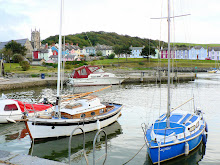
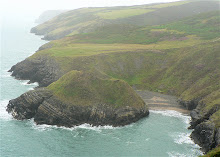
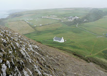
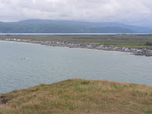
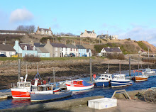
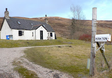
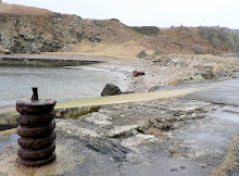
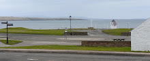
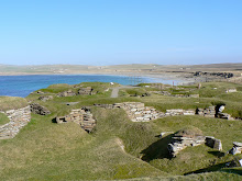
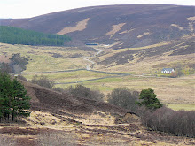
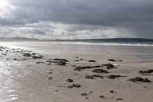
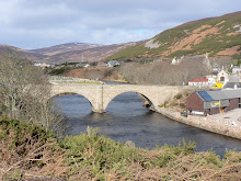
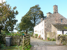
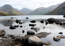
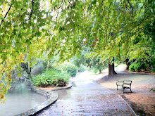
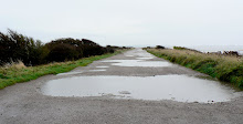
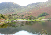
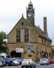
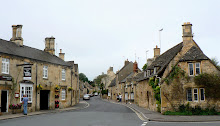
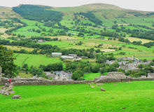
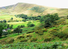
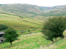
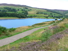
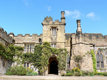
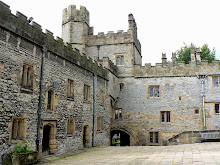
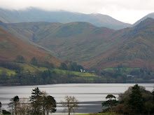
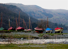
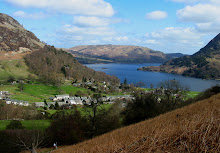
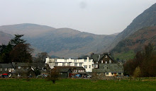
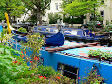
Within walking distance of Patterdale, surrounded by peaks and valleys, unspoilt by overt commercialism and yet within 5 short miles of the M6 and of Helvellyn, the village of Glenridding in Ullswater ticked all our boxes! Our accommodation was on the shores of Ullswater, the lake curving gently through nine miles of magnificent mountain scenery opposite the hotel, and what's more, there was a path curving around the foothills, waiting to be walked!

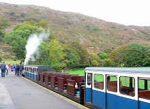
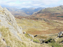
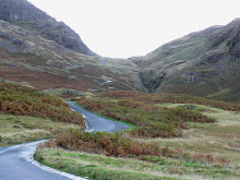
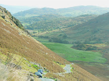
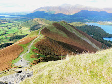
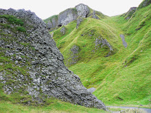
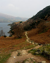
Our plan was to follow the 7 mile path to Howtown, then to pick up the lake steamer to Pooley Bridge before returning 'full steam ahead' back to Glenridding. So with a hearty hotel breakfast inside us we set off down the lane to the village of Patterdale, following the shores of Ullswater until we reached the head of the lake. Here the path crossed fields and a small beck, before taking us to the foot of Place Fell (657m). Our walk then hugged the shores of the lake before climbing gently across the undulating contours of the lower fell, (very Wainwright!).

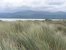
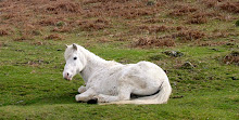
Although we hadn't climbed far up the fell, we enjoyed pretty views back across Ullswater to Glenridding. We also came across a beautiful pure white, but rather ghostly looking horse on the path, and after stopping to say hello continued on our way. But as we walked on, I felt compelled to keep looking back, feeling sure it would have mysteriously vanished, back to the ethereal fantasy world from which it had obviously come. But it was still there. Maybe the falling mist was playing tricks on my eyes!

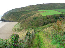
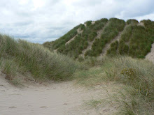
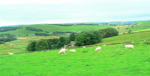
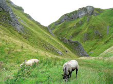
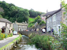
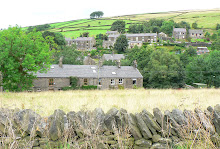
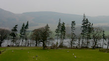
We continued along the foothills of Birk Fell and Sleet Fell, until they finally dropped us into the tiny village of Sandwick, which seemed to consist of a row of pretty terraced cottages, a handful of hungry sheep and a tiny stretch of sand with a huge view on the shores of the lake. After stopping to admire the pretty but misty views across Ullswater, the route then wound it's way back up through Hallinhag Wood along the base of Hallin Fell (388m).

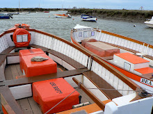
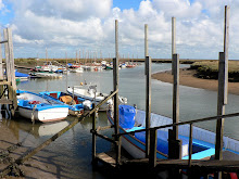
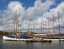
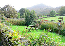
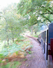
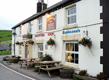
By the time we reached Howtown several hours had passed and we were pleased to stumble into the Howtown Hotel, where we enjoyed liquid refreshment in a tiny little daffodil-filled garden, (very Wordsworth!). With thirsts quenched but calves still tender we hobbled down to the jetty where our steamer, The Lady of the Lake, was waiting to transport us. Sadly the mist had descended on the lake obliterating all scenic views, but we nevertheless enjoyed our sail across Ullswater, through ever thickening mist, past various keen kayakers, and back to the jetty at Glenridding,

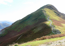
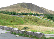
Glenridding is surrounded by peaks, the most dramatic of which is Helvellyn, flanked to the south east by the famous and renowned ridge, Striding Edge. At 949m, Helvellyn is not only the second highest mountain in the Lakes and in England, but it also happens to be located just 4 miles west of Glenridding and our hotel. The most common route to Striding Edge is from Patterdale, and it was from here that our second walk began.

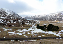
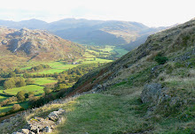
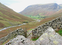
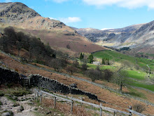
Okay, so I confess it was never our intention to climb up the mighty Helvellyn nor across the precipitous Striding Edge! We'd planned instead a lovely walk that was not too taxing, nor too steep, nor even too long, just a pleasant 4 mile undulating walk in the Grisedale Valley behind and between Patterdale and Glenridding.

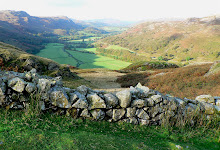
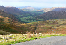
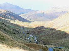
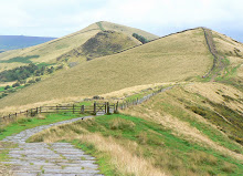
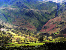
On a gloriously sunny day in April we set off from our hotel along the winding lane that curves around Ullswater for about a mile to the pretty village of Patterdale. Once we'd located our bearings, and the footpath, we turned off the road and followed the trail along the lower contours of Glenamara Park, with lofty views of Arnison and Black Crags (622m) above us to our left, sweeping views along the Grisedale Valley ahead, and the wooded Keldas (322m) up to our right - a 360 degree stunning backdrop to our walk.

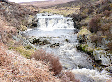
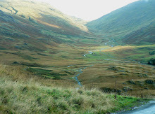
At around the half way mark we followed the path downwards into the valley basin at Thornhow, where we crossed Grisedale beck before the climb back up the other side of the valley. At this point it was just as if the whole area was a stage set for a stunning light show. And when the performance began, one hill after another was floodlit by swathes of golden sunlight all the way down the valley.

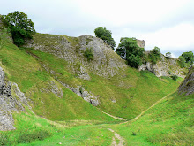
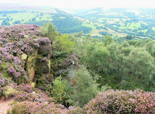
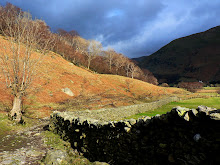
We headed up the valley towards Birkhouse Moor, a ridge that runs the length of the Grisedale valley, separating Glenridding and Patterdale Commons, and emptying into the head of Ullswater. There are small pockets of mixed woodland on the lower slopes and above these the valley wall is steep sided with some outcropping rock. Our route skirted Birkhouse Moor, taking us upwards, eastwards and through the pine-clad hillsides of Keldas.

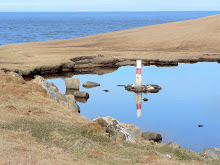
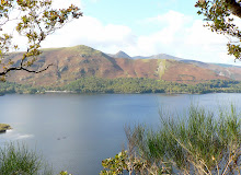
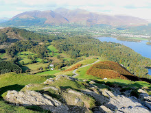
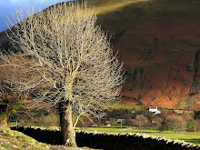
Keldas is separated from the main body of Birkhouse Moor by a small depression containing Lanty's tarn. This small body of water has taken it's name from Lancelot Dobson, an earlier landowner. It was later bought by the owners of Patterdale Hall, the Marshall family, and extended by damming. In addition to fishing, the tarn was used as a source of ice in winter, and the ice house still stands nearby. The summit of Keldas is privately owned but public access is permitted. Standing above the head of Ullswater it provides superb views down the lake, with the 'Keldas Pines' giving an excellent foreground for pictures.

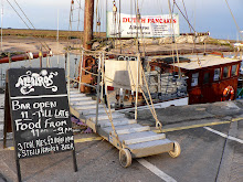
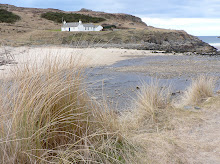
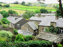
The last leg of our walk was the gradual descent back into Glenridding village, where, in stark contrast to the natural colours of the landscape in which we'd walked, we lunched in an bistro with bright orange walls covered in equally vibrant artwork - but the food was delicious!

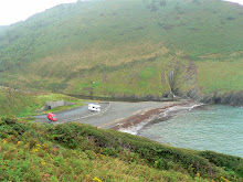
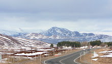
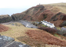
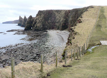
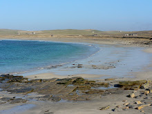
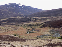
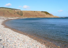
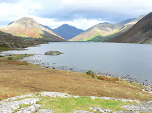
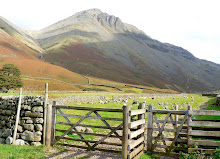
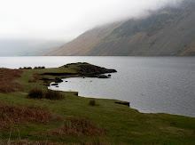
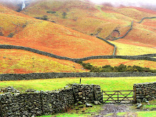
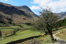
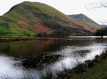
Just a few miles south of Glenridding is Brothers Water and another pretty walk. It lies in the Hartsop Valley at the foot of Kirstone Pass, where the road climbs from the valley of Patterdale before descending to the more visited areas of Ambleside and Windermere.

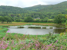
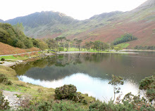
One of the smallest, shallowest and prettiest of the lakes in the lake District, Brothers Water is only about half a mile from tip to toe, and less than 1/4 mile wide. They say this lake can be classified in two ways: one of the Lake District's smallest lakes or one of it's largest tarns! Dorothy Wordsworth referred to Brothers Water as "... the glittering lively lake ...'. I just think of it as one of Cumbria's hidden little precious gems, and one that outshines many of it's flashier neighbours! However, it does have a rather sad, tragic history.

The lake was originally called Broad Water, a strange name, considering it's diminutive size, but it was apparently renamed in the Victorian period after two brothers were tragically drowned in the lake. Brothers Water is now owned by the National Trust, who manage it as part of a natural preservation scheme aimed at conserving the ecology, flora, and fauna of the area.

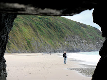
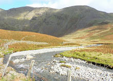
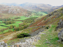
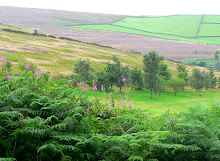
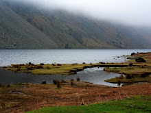
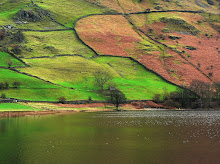
Our walk began at Cow Bridge, just north of Hartsop, off the A592. We followed the waymarked trail around the western perimeter of the lake to our left and through the thickly wooded skirts to our right, which on occasions overspilled onto the shore. But there was always a view to be had - of the picturesque pink and green patchwork fells across the lake, of their reflections in it's glassy surface, or of the reed beds at the northern head of the lake, creating more interesting patterns, and no doubt vital nesting homes for numerous breeds of water birds.

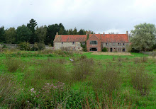
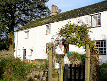
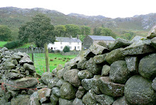
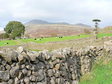
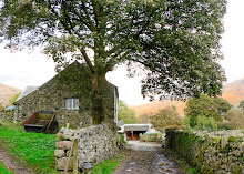
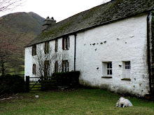
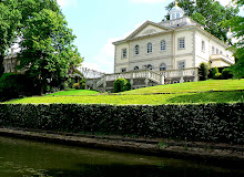
As we reached the head of the lake the valley floor became green, and the fell slopes became all shades of green, pink and mauve, including the trees! As we followed the trail further we reached the medieval farmhouse of Hartsop Hall, a pretty 15th century dwelling, now owned by the National Trust but leased to a local farmer.

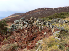
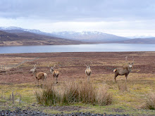
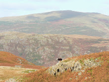
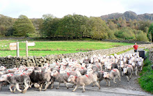
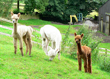
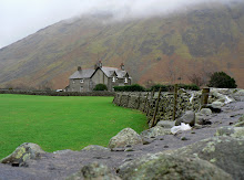
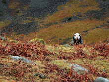
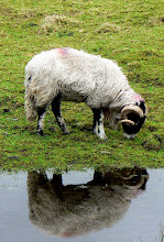
We didn't see the farmer, but met his herd of friendly and photogenic black cows! Not to be outdone, one of his sheep also muscled in for a photo shoot, going one better by providing us with a duplicate reflection! A little further on we came across the ruined remains of a dry stone wall sheep pen. Not medieval but it made a lovely frame to my photograph!

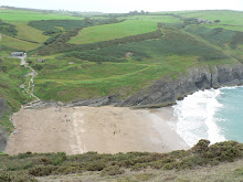
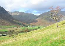
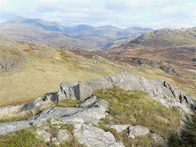
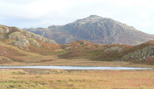
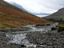
The south end of Brothers Water is particularly stunning, probably due to the unusual proportions of width and height within the valley - it's narrowness versus the height of 'High Hartsop Dodd', the majestic mountain, positioned at the head overlooking the whole valley. Standing at the foot of the High Hartsop Dodd seemed to create an 'Alice in Wonderland' illusion of a mountain much higher than it's 519m. This really is a breathtakingly beautiful little self-contained gem of a valley which must be hard to beat.

Any original intention we might have had of taking a circular walk was somehow lost at this stage, along with all signs of the trail. So rather than adding unnecessary miles to our walk, and equally unnecessary aches to our legs, we decided to hedge our bets and retrace our steps back to Cow Bridge and the car park.

But, thanks to Mother Nature, the return journey was by no means a 'repeat' walk in reverse. We were about to discover that this beautiful valley could get even better!

It's a well known fact that the weather can change very quickly and dramatically in the Lake District, but this is usually regarded as a negative 'turn for the worse'. When the weather 'turned' on that late afternoon in March, the whole valley metamorphisised.

The previously pallid grey of the sky turned a deep moody blue, long shadowy fingers descended into the valley feeling their way along the fell contours, shafts of sharp sunlight hit seemingly selected trees with the intensity of a laser beam, flooding their dark shapes and turning them a brillian gold, in stark contrast to the darkening valley behind.

This was the alternative side of Brothers Lake - threatening, powerful, moody, dramatic - but completely awesome.

Saturday 6 June 2009

London

London. Our great capital city. Also a major metropolis, global city of commerce, world financial centre; a leading influence on politics, culture, education, media and the arts; a capital steeped in history, populated by a multicultural melee and visited by 26 million tourists every year.

London is a remarkable city with a rich and limitless heritage upon which to draw. It is no surprise therefore that London has numerous attractions and famous landmarks, from all eras of its history. No matter where you are located within London, there seems a never ending list of things to do and places to see.

The majority of people who visit London do so because of the huge variety and choice of shops, theatres, museums, art galleries, palaces, parks, nightlife, eating establishments and entertainment. Plenty of scope then for the day trip that we were planning! But having lived in London and pretty much exhausted the tourist trail, we promptly ignored all the obvious attractions and headed instead for a day of waterside vistas.

One of the Capital's best kept secrets is the beautiful green corridor of The Regent's Canal, stretching eight and a half miles long and flowing from Little Venice through Camden and past Islington, Hackney and Tower Hamlets before it finally enters the Thames at Limehouse Basin in the East End. But unlike the canals that wind their way around fields and between towns, the Regent's Canal is tucked away behind Kilburn High Street, Maida Vale, London Zoo, Primrose Hill, and behind the gardens of the avant-garde and some of London's most exclusive and desirable addresses. In just 3 short miles our 'alternative London' walk along the tow path of Regent's Canal offered us views and images that we would not otherwise have seen, nor even known existed.

The Regent's Canal was built in the early 19th Century to link the River Thames at Limehouse to the Grand Union Canal junction at Paddington. One of the directors of the canal company was architect John Nash, famously commissioned by the Prince Regent (later George IV) to design Regent's park and the surrounding curved terraces. Nash's association with the Prince facilitated the Royal approval needed in naming the canal in his honour.

It was finally completed and opened in 1820 at a total cost of £772,000, twice the original budget. After major engineering difficulties and accusations of financial embezzlement, the Canal successfully carried 120,000 tons of cargo through London in its first year. Together with the Grand Junction Canal and the associated routes to the Midlands and north, the Regent's Canal formed an essential component in southern England's transport system. Huge quantities of timber, coal, building materials and foodstuffs were carried and long-distance traffic continued to use it into the 1960s. It was deemed a success back in 1820 and continues to be one today, offering a hidden tow-path of tranquility in an otherwise fast-track world.

The confluence of Regents Canal and the Grand Union Canal is a pretty and picturesque pool of water, home to a number of waterside cafes, pubs and eateries. This is Little Venice. Joining the walk here, just minutes from Paddington Station, we immediately stepped into an oasis of leafy calm.

The leafy theme continued downstream and also onto the narrowboats!
The pretty residential moorings of Blomfield Road are one of the most prestigious canal mooring sites in London. And here we saw flowers hung from hulls, roofs, boughs and sterns, planted in a variety of beautifully hand-painted receptacles of all shapes and sizes - troughs, kettles, pans, teapots, buckets and wheelbarrows. Such is the pride of their owners, even their boat moorings were decked out with potted palm trees and shrubs - mini patio gardens with a rather spectacular water feature!

Half a mile further downstream at the end of Blomfield Road the canal disappears into the Maida Hill Tunnel and underneath the captivating Cafe Laville. We weren't captivated enough to pay their prices for a cup of coffee, so continued on until we rejoined the towpath at Lisson Grove and continued on to Regents Park. Originally Nash intended to have The Regent's Canal running through the middle of the park although he was persuaded that the bad language of the Navvies would offend the refined residents of the area so altered his plans. Nash had plans to build 56 villas in Regent's Park, however only eight were completed. The beautiful white villas on the right were built to Nash's original designs during the late 1980s and early 1990s and drew inspiration from the architecture of ancient Greece and Rome in the Renaissance period.

Continuing along the towpath we passed under two bridges. The first is an aqueduct carrying the forgotten River Tyburn over the canal. The second is the notorious Maclesfield Bridge or "Blow up Bridge". Here, in 1874, a barge carrying gunpowder exploded and destroyed the bridge. Evidence of the explosion can be found on a nearby plane tree which survived the blast. Passing underneath the bridge the famous Snowdon aviary of London Zoo then came into view. Opened in 1965, the aviary was pioneering in engineering terms.

Ahead of us we saw the Feng Shang Chinese floating restaurant moored in Cumberland Basin. This arm of the canal used to stretch towards Euston station but was largely filled in with bomb rubble after the Second World War. At this point the canal took a sharp turn to the left towards Camden. Camden is best known for its alternative and vibrant market scene, which centres on a cobbled courtyard just off the canal. This is where we stopped for a much needed coffee and a chance to sit and drink in the incredible atmosphere and energetic personality that makes Camden so contagious.

Our second waterside wanderings were certainly atmospheric but not at all energetic, as we began it with an aerial 'flight' over the River Thames! The London Eye, at a height of 135 metres (443 ft), is the biggest Ferris Wheel in Europe, and has become the most popular paid tourist attraction in the UK, visited by over three million people a year. More importantly, it gave us the most amazing view of The River Thames, and our Capital.

The wheel carries 32 sealed and air-conditioned egg-shaped passenger capsules, attached to its external circumference, each capsule representing one of the London Boroughs. Each 10 tonne capsule holds 25 people, who are free to walk around inside the capsule, though seating is provided. It rotates at 26 cm (10 in) per second (about 0.9 km/h (0.6 mph) so that one revolution takes about 30 minutes. The wheel does not usually stop to take on passengers: the rotation rate is so slow that they can walk on and off the moving capsules at ground level. This is a significant and important fact, given that I usually have a problem with heights! But the speed of the Eye is so imperceptibly slow that it barely registered on my panic scale! Even when we reached the pivotal point before our descent, there was no real sense of height or fear. Just a feeling of awe at the stunning views across the whole of London.

After our 'flight' over the Thames we decided to 'sail' down it. We boarded our boat at Waterloo Bridge and began the 40 minute sightseeing cruise down river. To the accompaniment of a foreign 'specialist guide' who mostly stated the obvious, we left the shadow of the London Eye towering over the former GLC headquarters of County Hall, and headed downstream towards Westminster Bridge.

The name Westminster was historically used to describe the area around Westminster Abbey, the West Minster, or monastery church that gave the area its name, and which has been the seat of the government of England for almost a thousand years. We saw no signs of governance or political activity as we cruised past (no doubt they were in the House of Commons debating extravagant expense claims, or perhaps just relaxing in one of their well tended homes), so we turned our attention to the stunning Victorian gothic architecture instead.

Under Westminster and Charing Cross Bridges to our right, and in direct contrast to Westminster Palace, stands the unmistakable South Bank Centre, home to the Royal Festival Hall built in the contemporary Modernist style of architecture in the 1950s; the Haywards Gallery and controversial 1960's Brutalist architecture, and beyond it the National Theatre, built in the 1970s and notoriously described by the Prince of Wales as 'a clever way of building a nuclear power station in the middle of London without anyone objecting!'

Mirroring the white buildings of the South Bank Centre on the Thames Embankment is the Savoy Hotel, one of London's most prestigious and opulent hotels, built in 1889 and boasting an 'A-list-guest-list' which includes Monet, Whistler, Wilde and The Beatles (to name but a few favourites!). Further downstream towards Blackfriars Bridge on the right is the little gem that is Gabriel's Wharf, a riverside oasis and colourful arty enclave offering fairtrade furnishings, affordable artwork, crafty creations and refreshments.

Once under Blackfriars Bridge we had a spectacular view of 3 very different bridges spanning the river ahead, the famous 'wobbly' pedestrian Millenium Bridge, the 'first' and latest in a succession of London Bridges, and the iconic suspension bridge that takes it's name from the nearby Tower of London, Tower Bridge. But glances to either side of these bridges provided cultural history in boat-loads.

To our right the area known as 'Bankside', home to 'The Clink', notorious and infamous 12th Century prison. Further on the reconstructed early 17th Century Shakespeare's Globe Theatre, built in 1997 on the site of the original Globe. And towering above them all, the solid imposing structure of the former Bankside Power Station, now transformed into impressive and cavernous Tate Modern art gallery. And as we passed under the Millenium bridge, London's most famous dome came into view, framed by the alignment of the bridge and offering a postcard shot of Wren's 17th Century reconstruction and arguably his best showpiece, St Paul's Cathedral.

As we neared the end of our Thames Trip, we soaked in the sights of one of the oldest buildings in London, famous for it's White Tower, turrets, traitors, treason, torture and tourists. Apart from being home to royals over the centuries, it is also home to the Crown Jewels and the Ravens, without who (allegedly) the White Tower, the Monarchy and the whole Kingdom would fall. But, apparently, even the Ravens don't have any special royal dispensation or immunity. During the recent bird flu scare, they were themselves imprisoned in the Tower! Thankfully they didn't succumb to flu, or execution, and are free to peck and be raucous once again. Which also means the Kingdom won't fall, so we'll be able to explore more of London's landscapes in the future!