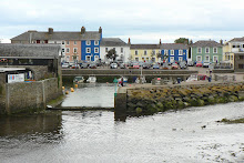
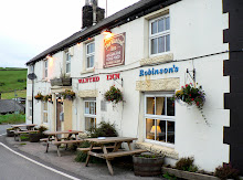
A late summer weekend break was much needed and Norfolk was the natural choice, for an unspoilt coastline, uncrowded towns, unlimited choice of places to explore, and an undemanding and short journey time. We decided to make our base Cromer, and had set our sights on The Paris hotel, overlooking the pier, and looking slightly less grand that it might have done in its heyday. We affectionately referred to it as our 'shabby chic' option. But it was not to be. Booking in advance was difficult, with priority given to coach-parties. The prospect of battling for a seat at breakfast resulted in a booking at our second choice. The Red Lion. This overlooked the sea too, and our 'superior room' was indeed a superior choice!
But as always, the journey is part of the holiday, and we took the opportunity to 'hop and stop' at regular intervals along the North coastline, starting with Winterton-on-Sea - a pretty village with several attractions. The beach was typical of many on this North Norfolk Heritage Coast. Wide sweeping sandy bays, flanked by dunes, walked by dogs and their owners, home to hardy seal colonies and loved by photographers! In spite of the grey skies and nip in the air we took our first walk along the pretty shoreline following the long winding trail of pink and red seaweed which the waves had deposited just for our photos, it seemed, before turning tide and retreating. But beyond the sea-shore the horizon was also offering opportunities.
A far distant wind farm punctuated the horizon, the giant majestic turbines just getting on with their work, unobtrusively, silently and photogenically. Last but not least, and clearly not wishing to be ignored, a small group of seals kept bobbing up out of the water, added interest and amusement to the crowd of onlookers (which equated to around 5 people and a couple of dogs). As if not to be outdone, a hobby (falcon), who was clearly also on holiday, was on the beach doing his own beachcombing - for food!
After a quick re-visit to Horsey Windpump, where the skies were even greyer than our first visit, we hopped up the coast to re-visit Sea Palling, which had made quite an impression on me previously. A turning too soon took us to Horsey Gap, a break in the dunes just south of Sea Palling, but it had a useful sea wall on which to eat our picnic!
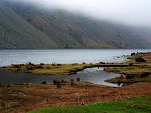
Sea Palling, like Winterton-on-Sea, is off the beaten track, quiet and un-commercialised. As with it's neighbour down the coast the turbine-edged horizon is still visible, but it also has the added interest (from a photographic viewpoint) of a line of sea defence barriers and boulders attempting to hold back the sea, and a concrete wall (with curve appeal!), doing its best to protect the dunes from further erosion - a reminder that the ebb and flow of the sea is not always as benign as it appears. Armed with photos and wind-chapped cheeks, we left the beach to find some Walls which were less defensive ... I chose a pecan and maple and enjoyed every last lick!
The last and longest stop-off en route to our base at Cromer was always going to be Happisburgh. Much publicised by the media, much battered by the sea and much photographed and loved by us! This is coastal erosion at its worst, crumbling cliffs at their most volatile and family homes at their most vulnerable, facing their inevitable fate.
Looking for all the world like a D-day scene from a World War II movie, the sea defences on the beach at Happisburgh do their best to prevent the forces of nature from reclaiming the land. Some would say a futile attempt, others that not enough is being done. Whatever stance is taken, the endlessly long line of posts, poles and ramps that line this shore continue to be smashed, twisted, ravaged and rusted by the relentless battering of the waves, making this one of the saddest yet most inspiring sights on any UK coastline. Man's attempt to protect the land from the sea is certainly a force to be reckoned with, but is surely no match for the forces of nature. But what we saw on our final stop of the day reminded us that nature can also be silently stunning.
As we approached Cromer the heavens opened! And whilst our Superior Room at The Red Lion gave us superior shelter, the views of the sun setting in a moody sky drew us back out - for a plateful of fresh Cromer Crab in the Garden Street Grill, followed by a the best vantage point for a sunset - the pier.
As crowds of Cromer holidaymakers bustled along the shiny, slippery wooden walkway for the 'Seaside Special' finale of the Season, keen to get out of the wind and rain, two hardier weekenders instead lagged behind, keen to stay outside and watch the weather unfold. The reward was a perfect rainbow arch over the sea, from the end of the pier to the end of the Cromer coastline. And as the sun set in the sky and Cromer turned pale pink, we turned in ourselves, tired but already looking forward to the day ahead.
On day 2 we awoke early to a blue, cloudless sky! Keen to make the most of such glorious weather we decided on a quick pre-brekkie walk - eastwards towards the colourful row of beach huts, then back to the pier, looking resplendent and altogether different from the previous evening. And after a hearty breakfast of homemade yoghurt, smoked salmon and scrambled egg, toast and marmalade and copious cups of coffee, we set off westwards along the North Norfolk Heritage coastline.
First stop was Sheringham, colourful flags draped across narrow streets, shops full of trinkets, pavements littered with tourists - so after a few of our own purchases we moved on to find somewhere that wouldn't litter our photographs!
Weybourne was a delightful surprise, and was officially nominated as my favourite beach of the weekend! Nature once again caught my breath. Norfolk's infamous expanse of blue sky was covered in fluffy white clouds in regular patterns; the North Sea had amazingly turned blue and was fringed with frothy white waves crashing onto the unspoilt, unadultered and deserted shingle beach, which in turn was flanked by miles of low, grass-topped, frilly sandstone cliffs which snaked along the coastline, inviting walkers with cameras and dogs to follow it!
Loathe as I was to leave Weybourne, we wanted to see so much more of this coastline, and whilst our next stop was an old favourite we had an ulterior motive for going there ... .
Blakeney Nature Reserve has so much to offer. Wildlife aside, there are colourful boats, curvacious creeks, crazy dog-owners and cream scones! We took advantage of them all, and didn't let the worsening weather deter us from enjoying a short walk along the creek. Neither did the crazy dog-owner let the creek deter him from rescuing his escaped dog from the far bank! Dressed only in his underwear and top, he was resolute in his quest as he waded waist deep in the muddy waters, watched by amused and amazed onlookers. He rescued his dog, but I imagine his pride and ego are still in the creek!
Our ulterior motive for stopping at Blakeney was to check out the departure point for our planned boat trip to Blakeney Point to see the Seals. Once we'd established that the boat left from Morston rather than Blakeney Quay, we set off on our quest to find 'Beans Boats' and moorings ... which turned out to be unmissable, well-sign posted and bright orange! Our penultimate and unplanned stop of the day was at a Duck Museum.
Well, a Tank Museum actually, but I still claim that the graphics on those brown information signs are open to misinterpretation! The Muckleborough Collection is Norfolk's largest working military museum, full of tanks, Yeomanry vehicles, guns and missiles, all waiting to be photographed. Getting up close and personal with a Doodle Bug and Harrier was an unexpectedly moving experience, and well worth the visit alone. But time and weather was drawing in, and we wanted to make one last stop before heading back to Cromer, to Wells.
Wells-next-the-Sea isn't anywhere near the sea. It used to be apparently. But silting has reclaimed the land, turning the area into salt marsh and creating a haven for bird life. We neither had the time nor the inclination for the long trek to the sea on this occasion, so instead took to the narrow, colourful and bustling back streets which are now a haven for tourism. Ominous clouds had followed us back to Cromer, and it soon became clear that there was only one way to spend the evening. The decision was unanimous ... we sat on the pier, eating fish 'n chips, whilst storm watching! The sky was thunderous, the reflected lighting over Cromer awesome, the occasion magical, and the fish 'n chips yummy!
The day of our Beans Boat trip was upon us, and after the storms of the previous evening, we anxiously looked out across the sea, hoping for a flat calm sea but anticipating a choppy churned up one! It was somewhere in between. And after another hearty breakfast (and sadly our last), we made tracks. With time to spare we were able to stop at West Runton, recommended by a friend as the 'type of beach I would like'. True enough, West Runton was deserted and dramatic. A line of craggy cliffs atop the beach, a line of dark defences along it and a band of sand on which to walk, twixt shingle and sea. It was a bracing one, but as luck would have it, a break in the clouds revealed blue sky ... and by the time we reached Morston Quay the blue of the sky was reflected in the creeks, and our boat trip was looking even more inviting.
We'd been told to look for a man in a bright orange top - Mr Baked Bean presumably. Given this information, we thought it was probably safe enough to walk a mile or so up creek without any danger of missing him! So there we were, up the creek without a paddle ... but with cameras to keep us occupied. By the time Mr Bean arrived in his bright orange top, the sky was looking stunning ... row upon row of ever-decreasing fluffy white cotton-wool balls were strung across the bluest of blue backgrounds. We queued, we paid, we boarded, we were off! About 20 of us bobbing up and down in Bean Boat, up the choppy creek, across the harbour and out to the sandspit - a sanctuary to some 5000 Norfolk seals.
We must have seen around 500 seals and a good few pups; the remainder of the colony would have been out at sea, doing what seals do when they're not lolling about on sandspits. Not that we were left without information ... Mr Bean took advantage of his captive audience and lost no time in feeding 'all aboard' with snippets of information about the feeding and breeding habits of Seals. And we left the Bean Boat well informed, well 'captured' and well peckish! Back on terra firma we indulged in freshly made, freshly caught crab sandwiches, ideal sea food after a ideal sea trip. We continued with our wildlife theme at the next and last planned stop of our weekend.
Pensthorpe Nature Reserve and Conservation Centre has been on my 'to do' list since Springwatch, and I was more that a little excited at the prospect of seeing first hand what I'd enjoyed on television. The fact that the blue sky had turned to grey and that rain was in the cool did nothing to dampen my enthusiasm. The Reserve had a lot to offer, and not just in terms of birds (though it has to be said that I've never seen so many species in such a relatively small area!). We decided to take a 'Discovery Tour', a ride in a Jeep trailer across the Reserve, and an ideal opportunity to see the extent of the site and what it offered. The driver/guide knew his stuff, could spot a kestrel at 500 metres and an emperor butterfly at 50 ... and all whilst driving around the winding tracks of the Reserve. He also flagged up various bat boxes, badger setts and birds of prey stands and nest sites which had been the focus of much camera attention on Springwatch. The tour ended with freebie Jordan's cereal bars ... not so random once you learn that the Jordan family now own Pensthorpe, and live on the Reserve!
The weather was gradually deteriorating as we set off on foot to check out the various recommended points of interest. Across walkways which spanned the ponds, lakes and mere; through the Millenium gardens, along the edge of the woodland area, down the bug walk, through the aviary, across the Conservation area and past 'Five Cottages', 'The Barn' from which Kate Humble, Chris Packham and the BBC film crew had presented Springwatch.
Points of interest? For one particular inquisitive bird (a Northern Bald Ibis), it was Alec's camera strap, who clearly wasn't interested in having his photograph taken. For another bird (a brightly coloured and love-sick pheasant) the only focus of interest was a potential female breeding partner, and she most clearly wasn't interest in him, and the pair darted between and around the shrubbery reminiscent of demented but comical cartoon characters!
My own points of interest included several camera-oblivious red squirrels, the plethora of colourful and photogenic ducks and geese who clearly owned Pensthorpe and waddled freely but noisily along and between the walkways, enjoying the attention of passing tourists who got in their way.
There was just time for a quick coffee in the Courtyard Cafe, and a warm up, before the gates shut behind us for the day, and reminded us that our weekend was also coming to a close. But first we had to find somewhere to eat ... easier said than done in rural Norfolk! We eventually found found on a Dutch floating Clipper, The Albatros.
Moored in Wells-Next-The-Sea, The Albatros is one of the oldest sailing ships still afloat. These days she is permanently moored and a tourist attraction, offering Dutch Pancakes and a different but fascinating historical atmosphere in which to eat them. The Albatros was built in Rotterdam in 1899 used as a cargo ship exporting grain from Denmark to Sweden. She even assisted Jewish refugees with their escape from Nazi Germany during WW2. Latterly she served Greenpeace as an environmental study centre for schoolchildren, before funds were cut... and today a couple of genial university students earn their keep by waiting on tables ... and entertaining tired, hungry, but very happy customers at the end of their packed photographic weekend in Norfolk.
But as always, the journey is part of the holiday, and we took the opportunity to 'hop and stop' at regular intervals along the North coastline, starting with Winterton-on-Sea - a pretty village with several attractions. The beach was typical of many on this North Norfolk Heritage Coast. Wide sweeping sandy bays, flanked by dunes, walked by dogs and their owners, home to hardy seal colonies and loved by photographers! In spite of the grey skies and nip in the air we took our first walk along the pretty shoreline following the long winding trail of pink and red seaweed which the waves had deposited just for our photos, it seemed, before turning tide and retreating. But beyond the sea-shore the horizon was also offering opportunities.
A far distant wind farm punctuated the horizon, the giant majestic turbines just getting on with their work, unobtrusively, silently and photogenically. Last but not least, and clearly not wishing to be ignored, a small group of seals kept bobbing up out of the water, added interest and amusement to the crowd of onlookers (which equated to around 5 people and a couple of dogs). As if not to be outdone, a hobby (falcon), who was clearly also on holiday, was on the beach doing his own beachcombing - for food!
After a quick re-visit to Horsey Windpump, where the skies were even greyer than our first visit, we hopped up the coast to re-visit Sea Palling, which had made quite an impression on me previously. A turning too soon took us to Horsey Gap, a break in the dunes just south of Sea Palling, but it had a useful sea wall on which to eat our picnic!
Sea Palling, like Winterton-on-Sea, is off the beaten track, quiet and un-commercialised. As with it's neighbour down the coast the turbine-edged horizon is still visible, but it also has the added interest (from a photographic viewpoint) of a line of sea defence barriers and boulders attempting to hold back the sea, and a concrete wall (with curve appeal!), doing its best to protect the dunes from further erosion - a reminder that the ebb and flow of the sea is not always as benign as it appears. Armed with photos and wind-chapped cheeks, we left the beach to find some Walls which were less defensive ... I chose a pecan and maple and enjoyed every last lick!
The last and longest stop-off en route to our base at Cromer was always going to be Happisburgh. Much publicised by the media, much battered by the sea and much photographed and loved by us! This is coastal erosion at its worst, crumbling cliffs at their most volatile and family homes at their most vulnerable, facing their inevitable fate.
Looking for all the world like a D-day scene from a World War II movie, the sea defences on the beach at Happisburgh do their best to prevent the forces of nature from reclaiming the land. Some would say a futile attempt, others that not enough is being done. Whatever stance is taken, the endlessly long line of posts, poles and ramps that line this shore continue to be smashed, twisted, ravaged and rusted by the relentless battering of the waves, making this one of the saddest yet most inspiring sights on any UK coastline. Man's attempt to protect the land from the sea is certainly a force to be reckoned with, but is surely no match for the forces of nature. But what we saw on our final stop of the day reminded us that nature can also be silently stunning.
As we approached Cromer the heavens opened! And whilst our Superior Room at The Red Lion gave us superior shelter, the views of the sun setting in a moody sky drew us back out - for a plateful of fresh Cromer Crab in the Garden Street Grill, followed by a the best vantage point for a sunset - the pier.
As crowds of Cromer holidaymakers bustled along the shiny, slippery wooden walkway for the 'Seaside Special' finale of the Season, keen to get out of the wind and rain, two hardier weekenders instead lagged behind, keen to stay outside and watch the weather unfold. The reward was a perfect rainbow arch over the sea, from the end of the pier to the end of the Cromer coastline. And as the sun set in the sky and Cromer turned pale pink, we turned in ourselves, tired but already looking forward to the day ahead.
On day 2 we awoke early to a blue, cloudless sky! Keen to make the most of such glorious weather we decided on a quick pre-brekkie walk - eastwards towards the colourful row of beach huts, then back to the pier, looking resplendent and altogether different from the previous evening. And after a hearty breakfast of homemade yoghurt, smoked salmon and scrambled egg, toast and marmalade and copious cups of coffee, we set off westwards along the North Norfolk Heritage coastline.
First stop was Sheringham, colourful flags draped across narrow streets, shops full of trinkets, pavements littered with tourists - so after a few of our own purchases we moved on to find somewhere that wouldn't litter our photographs!
Weybourne was a delightful surprise, and was officially nominated as my favourite beach of the weekend! Nature once again caught my breath. Norfolk's infamous expanse of blue sky was covered in fluffy white clouds in regular patterns; the North Sea had amazingly turned blue and was fringed with frothy white waves crashing onto the unspoilt, unadultered and deserted shingle beach, which in turn was flanked by miles of low, grass-topped, frilly sandstone cliffs which snaked along the coastline, inviting walkers with cameras and dogs to follow it!
Loathe as I was to leave Weybourne, we wanted to see so much more of this coastline, and whilst our next stop was an old favourite we had an ulterior motive for going there ... .
Blakeney Nature Reserve has so much to offer. Wildlife aside, there are colourful boats, curvacious creeks, crazy dog-owners and cream scones! We took advantage of them all, and didn't let the worsening weather deter us from enjoying a short walk along the creek. Neither did the crazy dog-owner let the creek deter him from rescuing his escaped dog from the far bank! Dressed only in his underwear and top, he was resolute in his quest as he waded waist deep in the muddy waters, watched by amused and amazed onlookers. He rescued his dog, but I imagine his pride and ego are still in the creek!
Our ulterior motive for stopping at Blakeney was to check out the departure point for our planned boat trip to Blakeney Point to see the Seals. Once we'd established that the boat left from Morston rather than Blakeney Quay, we set off on our quest to find 'Beans Boats' and moorings ... which turned out to be unmissable, well-sign posted and bright orange! Our penultimate and unplanned stop of the day was at a Duck Museum.
Well, a Tank Museum actually, but I still claim that the graphics on those brown information signs are open to misinterpretation! The Muckleborough Collection is Norfolk's largest working military museum, full of tanks, Yeomanry vehicles, guns and missiles, all waiting to be photographed. Getting up close and personal with a Doodle Bug and Harrier was an unexpectedly moving experience, and well worth the visit alone. But time and weather was drawing in, and we wanted to make one last stop before heading back to Cromer, to Wells.
Wells-next-the-Sea isn't anywhere near the sea. It used to be apparently. But silting has reclaimed the land, turning the area into salt marsh and creating a haven for bird life. We neither had the time nor the inclination for the long trek to the sea on this occasion, so instead took to the narrow, colourful and bustling back streets which are now a haven for tourism. Ominous clouds had followed us back to Cromer, and it soon became clear that there was only one way to spend the evening. The decision was unanimous ... we sat on the pier, eating fish 'n chips, whilst storm watching! The sky was thunderous, the reflected lighting over Cromer awesome, the occasion magical, and the fish 'n chips yummy!
The day of our Beans Boat trip was upon us, and after the storms of the previous evening, we anxiously looked out across the sea, hoping for a flat calm sea but anticipating a choppy churned up one! It was somewhere in between. And after another hearty breakfast (and sadly our last), we made tracks. With time to spare we were able to stop at West Runton, recommended by a friend as the 'type of beach I would like'. True enough, West Runton was deserted and dramatic. A line of craggy cliffs atop the beach, a line of dark defences along it and a band of sand on which to walk, twixt shingle and sea. It was a bracing one, but as luck would have it, a break in the clouds revealed blue sky ... and by the time we reached Morston Quay the blue of the sky was reflected in the creeks, and our boat trip was looking even more inviting.
We'd been told to look for a man in a bright orange top - Mr Baked Bean presumably. Given this information, we thought it was probably safe enough to walk a mile or so up creek without any danger of missing him! So there we were, up the creek without a paddle ... but with cameras to keep us occupied. By the time Mr Bean arrived in his bright orange top, the sky was looking stunning ... row upon row of ever-decreasing fluffy white cotton-wool balls were strung across the bluest of blue backgrounds. We queued, we paid, we boarded, we were off! About 20 of us bobbing up and down in Bean Boat, up the choppy creek, across the harbour and out to the sandspit - a sanctuary to some 5000 Norfolk seals.
We must have seen around 500 seals and a good few pups; the remainder of the colony would have been out at sea, doing what seals do when they're not lolling about on sandspits. Not that we were left without information ... Mr Bean took advantage of his captive audience and lost no time in feeding 'all aboard' with snippets of information about the feeding and breeding habits of Seals. And we left the Bean Boat well informed, well 'captured' and well peckish! Back on terra firma we indulged in freshly made, freshly caught crab sandwiches, ideal sea food after a ideal sea trip. We continued with our wildlife theme at the next and last planned stop of our weekend.
Pensthorpe Nature Reserve and Conservation Centre has been on my 'to do' list since Springwatch, and I was more that a little excited at the prospect of seeing first hand what I'd enjoyed on television. The fact that the blue sky had turned to grey and that rain was in the cool did nothing to dampen my enthusiasm. The Reserve had a lot to offer, and not just in terms of birds (though it has to be said that I've never seen so many species in such a relatively small area!). We decided to take a 'Discovery Tour', a ride in a Jeep trailer across the Reserve, and an ideal opportunity to see the extent of the site and what it offered. The driver/guide knew his stuff, could spot a kestrel at 500 metres and an emperor butterfly at 50 ... and all whilst driving around the winding tracks of the Reserve. He also flagged up various bat boxes, badger setts and birds of prey stands and nest sites which had been the focus of much camera attention on Springwatch. The tour ended with freebie Jordan's cereal bars ... not so random once you learn that the Jordan family now own Pensthorpe, and live on the Reserve!
The weather was gradually deteriorating as we set off on foot to check out the various recommended points of interest. Across walkways which spanned the ponds, lakes and mere; through the Millenium gardens, along the edge of the woodland area, down the bug walk, through the aviary, across the Conservation area and past 'Five Cottages', 'The Barn' from which Kate Humble, Chris Packham and the BBC film crew had presented Springwatch.
Points of interest? For one particular inquisitive bird (a Northern Bald Ibis), it was Alec's camera strap, who clearly wasn't interested in having his photograph taken. For another bird (a brightly coloured and love-sick pheasant) the only focus of interest was a potential female breeding partner, and she most clearly wasn't interest in him, and the pair darted between and around the shrubbery reminiscent of demented but comical cartoon characters!
My own points of interest included several camera-oblivious red squirrels, the plethora of colourful and photogenic ducks and geese who clearly owned Pensthorpe and waddled freely but noisily along and between the walkways, enjoying the attention of passing tourists who got in their way.
There was just time for a quick coffee in the Courtyard Cafe, and a warm up, before the gates shut behind us for the day, and reminded us that our weekend was also coming to a close. But first we had to find somewhere to eat ... easier said than done in rural Norfolk! We eventually found found on a Dutch floating Clipper, The Albatros.
Moored in Wells-Next-The-Sea, The Albatros is one of the oldest sailing ships still afloat. These days she is permanently moored and a tourist attraction, offering Dutch Pancakes and a different but fascinating historical atmosphere in which to eat them. The Albatros was built in Rotterdam in 1899 used as a cargo ship exporting grain from Denmark to Sweden. She even assisted Jewish refugees with their escape from Nazi Germany during WW2. Latterly she served Greenpeace as an environmental study centre for schoolchildren, before funds were cut... and today a couple of genial university students earn their keep by waiting on tables ... and entertaining tired, hungry, but very happy customers at the end of their packed photographic weekend in Norfolk.