It had been quite a dilemma deciding exactly where our holiday should be based for our foray into the 'Far North Highlands'. We wanted to explore completely new and unknown territory; to see remote areas, mountains, to cover as much of the East, North and West coastlines as was humanly possible in a week, to stand on the tip of mainland UK, to visit The Orkneys - and to stay in an isolated crofters cottage central to everything on our wish list! But it took my tenacious and pedantic nature some considerable time to accept that something would have to 'give', and after a crash course in Highland geography and the road networks it became obvious we would have to forego 'Mountains' and the 'West Coast' for a future foray. As The Orkneys was top of the list then our base would need to be relatively close to the North and East coasts, ie the districts of Sutherland and Caithness, aka 'The Peatlands' and 'Flow Country.' The perfect cottage was located ... 40 miles South of John O'Groats, 8 miles inland from the East Coast, in the middle of nowhere and 600 miles from home! The holiday had begun ... but the epic journey still lay ahead ... .
We had two options. Plan A involved a flight to Inverness plus a hire car for the week; Plan B involved a very long but scenic drive, and our own comfortable car with big boot. Plan B was eventually voted favourite by the driver, and endorsed by the passenger! When 13th March arrived we were catapulted into the holiday by an early dawn alarm at 4.00 am and we were soon well on our way on the largely traffic-free roads. We crossed the Scottish border after 5 hours and 300 miles, and enjoyed a welcome break at a 'Welcome Break' on the Motorway ... but we were still only half way to our final destination! A further 200 miles and we were ready for lunch. A picnic in the Cairngorms, surrounded by the stunning snow-covered peaks of Aviemore was an unexpected treat ... but the biting cold wind a chilling reminder of what we might have to expect for the week.
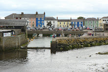
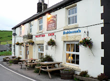
After a further brief stop at Cromarty en route (for no reason other than hearing the name on the BBC Shipping Forecast for many years), we arrived in the pretty coastal town of Helmsdale around 4.00 pm, 600 miles on, 11 hours after setting off, and with enough daylight left to check out our local town's attractions and amenities, before driving the final 8 miles of our epic journey up the Kildonan Valley to our cottage. And after a brief phone call to owner of the cottage to let her know we were arriving soon, we also had to stop for some coal for the fire!
The road to Kirkton Cottage was filled with eager anticipation and excitement! It was also one which exceeded our expectations for a peaceful, remote holiday location. As the narrow single-track road left Helmsdale far behind, it continued on its way, twisting and turning along the pretty banks of the River Helmsdale, flanked by huge heather-clad hills and punctuated every mile or two along the way with the occasional crofter's cottage with puffs of smoke swirling up from their chimneys (maybe the 'Clean Air Act of 1952 is not applicable in such remote rural areas). But it was quite clear that this valley belonged not to the cottage owners, but to the herds of sheep and red deer who momentarily stopped grazing to check out who was driving on their road and through their landscape. If we were in any doubt about it this point was reinforced on arrival at the cottage, as, fixed to the gatepost was a sign saying, 'Shut the gate to keep the deer out.' Our wildlife and landscape holiday was off to a good start ... .
The plan for Day 2 was an exploration of the east coast from Helmsdale up to John O'Groats, some 40 miles. Our first stop was unscheduled, as we pulled off the coastal road where the sign 'Site of Badbea Clearance Village' caught our attention. And after a short walk across bracken and heather clad land we arrived on the edge of a stunning cliff, where a dozen or so stone ruins of a village settlement were left clinging to the land, still perched precariously on the cliff top over the rocky shore far below, overlooking the sea. Just 100 years ago, a thriving self-sufficient fishing, farming and craft community, before being 'cleared away' for more lucrative sheep farming by the 'soon to be even wealthier' Duke of Sutherland, whilst its displaced community emigrated to New Zealand and North America. Next stop Berriedale, planned and researched!
The online 'guide to Berriedale' had warned that the stretch of road through this quaint, quiet coastal village twisted and turned sharply and steeply, and it didn't lie! More like a hairpin bend on a Monte Carlo Rally, the route took us beyond the village to a high viewpoint layby, where we were able to get out of the car and view the impressive scenery which had been a blur throughout the white-knuckle ride that got us to that point. The village itself was as far removed from Monte Carlo as it could be ... no tourists or trappings, tucked at the based of a steep wooded valley, carved by 2 rivers, overlooked by 2 two crenellated towers on the hillside (built by the Duke of Portland to highlight the location of the river mouth to fishermen), and edged by a deserted beach with derelict cottages, begging to be renovated. A steep descent, on foot, turned out to be worth any pain in the calf muscles! Once across the swaying pedestrian suspension bridge which spanned the river, we spent a contented hour with our cameras before wending our way to the next stop, another unplanned gem with a gem of a name too - Latheronwheel!
We headed straight for Latheronwheel harbour and as luck would have it, had it all to ourselves. No people, no boats, no activity, just an understated wealth of natural beauty. A sleepy sheltered harbour, an ancient grass covered pedestrian bridge across the river that separated beach and harbour (the 3rd Thomas Telford bridge we'd seen in 2 days) and an isolated, deserted and derelict cottage on the beach, looking for all the world as if it had been lifted from the pages of a Daphne du Maurier novel. Our first picnic of the week was enjoyed on the harbour before moving on to Wick, a familiar name, a pretty photo on the 'online guide', and a chance to fill up with petrol (and one not to be overlooked, given the dearth of towns in Caithness).
Well, Wick was good for petrol, and a Cadbury's Creme Egg treat, but we decided to head off for the famous John O'Groats, more out of a desire to 'tick off' this famous landmark than out of any high expectation of a site of natural beauty. We weren't disappointed! John O'Groats is what it is, a tourist landmark denoting the most north-easterly point on the UK mainland. NB: Not the most northerly. This is accredited to Dunnet Head, a couple of miles further west. But it was good to see it, and in its favour it had a treasure trove of a gift shop, and the most welcome Costa coffee in Caithness! It also gave us our first exciting views of The Orkneys. But first we wanted to check out Duncansby Head, famous for its impressive rock stacks.
After a short 2 mile drive west from John O'Groats, we parked at Duncansby Lighthouse ready for a 2 mile walk across the headland to the Stacks, and back. With no other cars or people in view (and bearing in mind the uninterrupted views across the wide expanse of Caithness probably span 40 miles east and southward), we enjoyed a peaceful and bracing walk, hugging the rugged coastline. The cliffs were very impressive, very sheer, very photogenic and very full of seabirds nesting precariously on narrow ledges. Impressive as it was, we decided it was time to move on to our last stop of the day before 'light stopped play'. Dunnet Head, the most northerly point of mainland Britain, had a lot more going for it than John O'Groats - for whatever reason it is not acknowledged as a tourist landmark and is therefore devoid of commercialism. Dunnet Head houses an impressive and crucial lighthouse, but is also the location of two WWII radar stations and (in warmer weather) home to North Atlantic puffins and a multitude of other seabird populations. It also gave us another viewpoint of The Orkneys, and made us more determined than ever to make this special trip sooner, rather than later in the week.
Having focused on coastal routes, we decided that day 3 should be spent exploring the hinterland of Sutherland. There is only a handful of roads covering this remote area, so the A897 leading north-west from our cottage up the valley was the natural, or Hobson's choice. The plan was to drive to Kinbrace then circle around and down Strath Naver heading southwards towards Lairg and back up the coast to Helmsdale, a round trip of some 100 plus miles. After stopping for a picnic by the roadside, sharing the stunning views of snow-topped mountains across the valley with the locals (who were themselves tucking into bracken and heather), we moved on.
I was keen to see Altnaharra en route, simply because it made headline news on BBC TV in January, as the coldest reported place in Britain so far this year (2010). I remember watching the report and wondering how such a remote, tiny community could survive in temperatures of -22.3C, in a place looking for all the world like the outer reaches of Alaska. Altnaharra is 82 miles north of Inverness, has 10 houses, a church and a hotel, with a likely population of around 30 hardy souls, 300 red deer and 3000 sheep! It looked a good deal warmer than it had on the news report but was every bit as remote as I'd expected.
The return journey southwards down the Strath Naver gave us mile upon mile of photo opportunities - twisty narrow roads, flanked by mountains, stream and waterfalls, lit up by a rainbow - but no pot of gold at the end, just the town of Lairg which failed to meet our expectations of a much needed coffee stop. A brief stop by Loch Shin and a quick shop for 'provisions', and we were on our way again through Golspie, past Dunrobin Castle (sadly out of season and shut) and onto Brora. This little town was sleepy but self contained. It had a wide sweeping beach, a pretty harbour, a clock tower, and most importantly, a quaint little coffee shop! I say a coffee shop, but it also tripled up as a care, florist, and picture framing shop. A shared family concern. I say shared, but I really mean unfairly shared! 'Mrs cafe owner' baked scones, served customers, worked the till, arranged and sold the floral displays, cleared the tables and washed the dishes. 'Mr picture framer' pottered around in the back of the shop on his own, looking busy ... :D We didn't disturb him by buying a picture!
Day 4 was Orkney Day! Our early morning alarm call galvanised us into action and we were soon heading the 40 plus miles northwards to Gills Bay to catch our 9.30 am ferry - the Pentalina. Our enthusiam to reach our destination without delay gave us time to spare, so we stopped off at John O'Groats in the hope of a quick coffee - sadly there was no hope, no coffee, no human life to be seen, only Eric the Viking. But nothing would dent our enthusiasm as we drove the few short miles westwards to Gills Bay. And as we rounded the harbour wall the sun came out to make things perfect!
Our departure point had not been our first choice, but had instead been decided for us. On checking the ferry sailing times we had been dismayed to find that passports were needed for identification purposes - and ours had purposely been left behind along with the decision to drive rather than fly to Scotland! Thankfully Pentland Ferries was the only company sailing to Orkney which didn't insist on this, and we couldn't have been more relieved and happy with their decision to exclude this condition. Gills Bay might not have been the prettiest harbour, but it was fit for purpose, and enabled us to get on our way ... in a fair amount of style too, as the ferry turned out to be a smart, impressive Catamaran. With more containers on board than passengers, our trip across the Pentland Firth was calm, peaceful and quite sunny ... past the Islands of Stroma, Swona, Hoy, Flotta and South Ronaldsay, into Scapa Flow, where we were deposited at St Margarets Hope ready to start our exploration of these purportedly beautiful islands. We were not to be disappointed.
Our aim was to see as much of the largest island as was possible in a day, and we had ear-marked several 'must sees' on the west coast. But even the drive to the 'West Mainland' was an adventure, as we 'island-hopped' across the famous 'Churchill Barriers' between South Ronaldsay and Burray, across to Glimps Holm, and Lamb Holm, then East Mainland and finally onto West Mainland. The Churchill Barriers were built in WW2 in response to the sinking of HMS Royal Oak by U47, which entered Scapa Flow via Holm Sound. 883 crew were killed, and within a month Winston Churchill visited Orkney and ordered that work should commence on the construction of 4 permanent 'defence' barriers linking together the chain of islands. Ironically they were completed just in time for the war's end, but 550 Italian prisoners of war who worked on the project have instead left a transport network legacy for Orcadians and visitors alike. Across the first such barrier we stopped at a unwitting but fitting tribute to the POW's - a charming Italian Chapel, which they had converted from 2 Nissen huts into a unique place of worship and a stunning representation of Italian Rennaisance art, complete with a gilded frescoed vault.
As we snaked our way between and across the islands, past the tragic and eerie half sunk warships and scenes of naval embarrassment from 1939, the magic of Orkney started to shine through. It might have been the luminous light; the low lying sparsely populated islands; the intensity of green fields against a mauve-blue sky; the sense of complete distance and remoteness from mainland UK; the remnants of ancient Neolithic/Viking/Celtic history, or maybe a combination of them all. Whatever it is that gives these islands their unique quality was in evidence that day, and will remain with me.
The main highlight of the day was Skara Brae. One of the earliest examples of a 'village' or community of individual dwellings, incredibly 5000 years old, unearthed by a storm in 1850 to reveal the most perfectly preserved site of its kind in Northern Europe. The fact that it overlooks what must be one of the most remote and stunning white curved beaches in the UK only adds to the mystique and mystery of this very special heritage site. The Bay of Skaill and its revelations need to be experienced to be believed. With dressers, beds, lintels, cupboards, rooms, doorways and corridors all still intact, Skara Brae has opened up many of its secrets, but tantalisingly hasn't revealed any tangible evidence to suggest why its inhabitants abandoned their innovative community and way of life. We too had to abandon this magical place to continue our exploration around the coast, with what little time we had left on Orkney.
From the magic and mystery of Skara Brae to the mystical and iconic setting of the Ring o'Brodgar. As if deliberately hidden from the view of passing travellers, we eventually found this prehistoric monument in the centre of a massive natural 'cauldron' formed by the hills of the surrounding landscape. Built somewhere between 2500 and 2000 BC this Neolithic stone circle is 104 metres wide and is the 3rd largest in the British Isles. Thought to have originally contained 60 megaliths, only 27 remain today. To see this remarkable site in the equally remarkable setting of Orkney and with the sun setting in the late Spring sky was yet another memory that will stay with me. And so, loathe as we were to leave this awesome archipelago, we headed off back to catch our ferry and to return to Kirkton Cottage, our Highland home for just 2 more days.
After our full day in the Orkneys we decided to spend Day 5 locally, in our 'own' Strath Kildonan. The weather was dry, if not bright and sunny, but we were hoping to strike gold regardless! Back in 1818 a gold nugget was found in the Helmsdale river, and some some 50 years later Helmsdale had its own goldrush! Just a few miles up the valley from Kirkton Cottage, legend has it that £12000 of gold was found in the hills around what is now called Baile an Or. As is often the case where money is concerned, greed and conflict eventually ended the gold rush, when the Duke of Sutherland found he was losing more potential income from the 'sheep, fishing & shooting fraternity' than he was gaining from the gold prospectors. 100 years on, this didn't prevent 2 tourists from scanning the river for glittering nuggets! Our walk along Suisgill Valley followed the course of the twisting and babbling Burn. The path initially hugged the waters edge but in places we were forced upwards by steeply and deeply thicketed banking, which gave us alternative but amazing views down and across the valley. Five or six miles later, after aborting our searching for gold, and a route across the river that didn't involve getting wet feet, we headed back to the car, empty handed but with dry feet. And whilst we hadn't found gold, we had enjoyed a peaceful walk in a perfectly natural landscape, home to wild red deer and Felix. Felix was the tiny, colourful but frightened frog on our path who covered his head with his paws to protect himself from being trodden on - my precious little nugget of dark green and gold.
After a picnic lunch we decided to venture across the valley and venture down a single track road we'd passed a few times, to see where it lead us. We were so glad we did! After crossing the little bridge which spanned the Helmsdale river, the narrow road wound onwards and upwards out of the valley. We stopped on the road side when a wide expanse landscape photo opportunity offered itself, and noticed a familiar looking 'spec' on the far side of the valley ... it was Kirkton Cottage, looking more beautiful and remote than we had seen it before (see photo). Moving onwards and upwards once more, we still hadn't passed a single car and the only signs of life around were deer and sheep. The road turned and levelled, and as it did so we found ourselves in the next valley, and facing another jaw-dropping view. This was Glen Loth. A huge, remote landscape enclosed on all sides by mountains and with just one narrow grass-covered track through it. As we descended into the valley we passed the remains and ruins of a previous community, and the standing standing stones of an even earlier one. We drove through the valley in complete silence, overawed by the incredible raw beauty and sense of complete isolation. No people, cars, buildings or indications that people had ever driven through Glen Loth - even the road was slowly being reclaimed by the land, with clumps of grass and weeds drifting, rooting and sprouting into life from adjacent land into the cracks and potholes. For the first time in my life I could imagine how a time traveller might feel being transported back 100 years ... . Some 12 miles on we emerged somewhat unexpectedly on the A9 coast road, back to cars, people, civilisation, 2010 ... and frogs!
On the last leg of our journey back to the cottage we noticed the road was littered with mud, or something. Then a few pieces of mud hopped, and we realised that a whole army of frogs was in the process of crossing the road to get to the river. Not just in one place, but along the 5 mile remaining stretch of road leading to Kirkton Cottage! Avoiding every one of the 1000s of frogs doing their 'green cross code hop' was impossible, but we steered our way slowly and cautiously along the road, meeting more 'life' in 15 minutes than we had encountered in the whole of our week to that point!
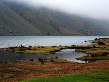
Day 6 had a false start, or to be more accurate, a leaky start. We had planned to explore the North Coast as far west as possible, given the mileage and time constraints. A very nice man in a backstreet Helmsdale garage checked the car over and tentatively gave us the thumbs up to proceed with our day. So we tentatively jumped back in the car and tentatively drove north with one eye on the road and three on the water temperature gauge! Our first stop was Dunnet Bay. We'd ended Day 2 at Dunnet Head, as the sun was sinking in the sky behind the most Northerly point on mainland UK. This was an opportunity to enjoy the 2 mile wide curved expanse of white sandy beach, and a picnic! With the exception of a woman and her dog we had the whole bay to ourselves, with watery views stretching across the Pentland Firth to distant Iceland, Greenland and beyond. Sadly the views became even more watery as the rain fell and stopped picnic plans! So we jumped back in the car and headed for Strathy Point, yet another of the strategic lighthouse sites along this craggy and dangerous coastline. But on this day it looked craggy and friendly, lit by blue sky and sun, giving us lots of photo opportunities!
Continuing westward across the 'top of mainland UK' we arrived at the charmingly named 'Bettyhill'. The bay was equally appealing. A pretty, peaceful and remote bay, entirely natural, with no trappings of tourism. An innocently cute name for a place re-named by the person responsible for the 'Highland Clearances' of 15000 people off Betty Sutherland's heavily populated estate between 1811 and 1821. Betty, aka the Countess of Sutherland, took unusual steps to build a replacement village near the coast, and Bettyhill is a legacy of those times. Wealthy landowners (Duke & Duchess of Sutherland) had brutally dispossessed tenant farmers of their land to use it for extensive and more lucrative sheep farming. Thousands of peasant farmers fled from their homes, and when faced with famine had no option but to emigrate. We had no option but to continue to our last stop of the day, which was also the most westerly point of our holiday, the Kyle of Tongue.
After 50 miles of driving, Ben Loyal was a sight for sore eyes (see photo). We drove down to the Kyle (Channel) and reflected on Scottish history once more before wending our way 'home'. In 1746 the ship 'Hazard' carrying £13K in gold coins to fund Bonnie Prince Charlie's rebellion fled into the Kyle of Tongue to evade HMS Sheerness ... and the gold was thrown into the Loch by the crew before they were captured. Most of the gold was recaptured by the government, so we didn't hang around waiting for the tide wash up our fortune. Instead we continued on our way down Strath Naver to Kildonan - a particularly scenic route made all the more majestic by a group of red deer who were quite clearly the landowners (see photo).
Day 7 had arrived, the final day of our holiday. We wanted to adopt more leisurely pace on the day before our epic journey home, so decided to check out our local town Helmsdale and the surrounding area. Helmsdale is probably best known for its bridges, and these span the mouth of the River Helmsdale which flows up the valley (Strath Kildonan) to Kirkton Cottage. The prettiest by far is down to the handiwork of Thomas Telford, built in 1811. Until recently this bridge formed part of the main A9 road north, but has thankfully been replaced further downstream to protect it from the heavy traffic flows. At the mouth of the river is an imposing statue - known as Helmsdale's retaliation to the Duke of Sutherland's 100' tall statue in Golspie further down the coast. 'The Emigrants' statue depicts and commemorates the achievement of thousands of Scots who left the Highlands during the Clearances of the 19th century. A clever and touching memorial to the Emigrants, built in stark, and cleverly understated contrast to the overstated, oversized glorification of wealth & land ownership just a few miles to the south.
Having battled with high winds on the cliff top, we decided to take a walk at sea level up the coast from Helmsdale, a route we had only driven to date. When we reached the pretty little harbour, it became clear the wind was equally strong at ground level! Barely able to stand upright, we fought against strong gusts until we reached the relative calm of a pretty stretch of coastline. We followed the beach from bay to bay, bright blue skies above us and beaches brimming with pretty stones and shells below us .. and all the while not a soul in sight, just nature and Helmsdale at its very best.
Our unplanned, unanticipated but truly memorable coastline walk was a perfect 'last activity' for the week. It ended in Strath Ullie Crafts Shop, a delightful Aladdin's Cave of unique and very reasonably priced local crafts, where we had difficulty in restricting our purchases to just a few mementoes of our time in the Highlands! The day ended in style with fish and chips from the local (but TV renowned) chippie in Helmsdale, and was a fitting end to what had been a fascinating insight into area of the UK that neither of us knew or had any pre-conceptions about. It will be remembered for many things, but especially The Orkneys and Strath Kildonan, our base for the week and one of the most stunning locations we have stayed in. The Highlands score very highly in our holiday ratings!
We had two options. Plan A involved a flight to Inverness plus a hire car for the week; Plan B involved a very long but scenic drive, and our own comfortable car with big boot. Plan B was eventually voted favourite by the driver, and endorsed by the passenger! When 13th March arrived we were catapulted into the holiday by an early dawn alarm at 4.00 am and we were soon well on our way on the largely traffic-free roads. We crossed the Scottish border after 5 hours and 300 miles, and enjoyed a welcome break at a 'Welcome Break' on the Motorway ... but we were still only half way to our final destination! A further 200 miles and we were ready for lunch. A picnic in the Cairngorms, surrounded by the stunning snow-covered peaks of Aviemore was an unexpected treat ... but the biting cold wind a chilling reminder of what we might have to expect for the week.
After a further brief stop at Cromarty en route (for no reason other than hearing the name on the BBC Shipping Forecast for many years), we arrived in the pretty coastal town of Helmsdale around 4.00 pm, 600 miles on, 11 hours after setting off, and with enough daylight left to check out our local town's attractions and amenities, before driving the final 8 miles of our epic journey up the Kildonan Valley to our cottage. And after a brief phone call to owner of the cottage to let her know we were arriving soon, we also had to stop for some coal for the fire!
The road to Kirkton Cottage was filled with eager anticipation and excitement! It was also one which exceeded our expectations for a peaceful, remote holiday location. As the narrow single-track road left Helmsdale far behind, it continued on its way, twisting and turning along the pretty banks of the River Helmsdale, flanked by huge heather-clad hills and punctuated every mile or two along the way with the occasional crofter's cottage with puffs of smoke swirling up from their chimneys (maybe the 'Clean Air Act of 1952 is not applicable in such remote rural areas). But it was quite clear that this valley belonged not to the cottage owners, but to the herds of sheep and red deer who momentarily stopped grazing to check out who was driving on their road and through their landscape. If we were in any doubt about it this point was reinforced on arrival at the cottage, as, fixed to the gatepost was a sign saying, 'Shut the gate to keep the deer out.' Our wildlife and landscape holiday was off to a good start ... .
The plan for Day 2 was an exploration of the east coast from Helmsdale up to John O'Groats, some 40 miles. Our first stop was unscheduled, as we pulled off the coastal road where the sign 'Site of Badbea Clearance Village' caught our attention. And after a short walk across bracken and heather clad land we arrived on the edge of a stunning cliff, where a dozen or so stone ruins of a village settlement were left clinging to the land, still perched precariously on the cliff top over the rocky shore far below, overlooking the sea. Just 100 years ago, a thriving self-sufficient fishing, farming and craft community, before being 'cleared away' for more lucrative sheep farming by the 'soon to be even wealthier' Duke of Sutherland, whilst its displaced community emigrated to New Zealand and North America. Next stop Berriedale, planned and researched!
The online 'guide to Berriedale' had warned that the stretch of road through this quaint, quiet coastal village twisted and turned sharply and steeply, and it didn't lie! More like a hairpin bend on a Monte Carlo Rally, the route took us beyond the village to a high viewpoint layby, where we were able to get out of the car and view the impressive scenery which had been a blur throughout the white-knuckle ride that got us to that point. The village itself was as far removed from Monte Carlo as it could be ... no tourists or trappings, tucked at the based of a steep wooded valley, carved by 2 rivers, overlooked by 2 two crenellated towers on the hillside (built by the Duke of Portland to highlight the location of the river mouth to fishermen), and edged by a deserted beach with derelict cottages, begging to be renovated. A steep descent, on foot, turned out to be worth any pain in the calf muscles! Once across the swaying pedestrian suspension bridge which spanned the river, we spent a contented hour with our cameras before wending our way to the next stop, another unplanned gem with a gem of a name too - Latheronwheel!
We headed straight for Latheronwheel harbour and as luck would have it, had it all to ourselves. No people, no boats, no activity, just an understated wealth of natural beauty. A sleepy sheltered harbour, an ancient grass covered pedestrian bridge across the river that separated beach and harbour (the 3rd Thomas Telford bridge we'd seen in 2 days) and an isolated, deserted and derelict cottage on the beach, looking for all the world as if it had been lifted from the pages of a Daphne du Maurier novel. Our first picnic of the week was enjoyed on the harbour before moving on to Wick, a familiar name, a pretty photo on the 'online guide', and a chance to fill up with petrol (and one not to be overlooked, given the dearth of towns in Caithness).
Well, Wick was good for petrol, and a Cadbury's Creme Egg treat, but we decided to head off for the famous John O'Groats, more out of a desire to 'tick off' this famous landmark than out of any high expectation of a site of natural beauty. We weren't disappointed! John O'Groats is what it is, a tourist landmark denoting the most north-easterly point on the UK mainland. NB: Not the most northerly. This is accredited to Dunnet Head, a couple of miles further west. But it was good to see it, and in its favour it had a treasure trove of a gift shop, and the most welcome Costa coffee in Caithness! It also gave us our first exciting views of The Orkneys. But first we wanted to check out Duncansby Head, famous for its impressive rock stacks.
After a short 2 mile drive west from John O'Groats, we parked at Duncansby Lighthouse ready for a 2 mile walk across the headland to the Stacks, and back. With no other cars or people in view (and bearing in mind the uninterrupted views across the wide expanse of Caithness probably span 40 miles east and southward), we enjoyed a peaceful and bracing walk, hugging the rugged coastline. The cliffs were very impressive, very sheer, very photogenic and very full of seabirds nesting precariously on narrow ledges. Impressive as it was, we decided it was time to move on to our last stop of the day before 'light stopped play'. Dunnet Head, the most northerly point of mainland Britain, had a lot more going for it than John O'Groats - for whatever reason it is not acknowledged as a tourist landmark and is therefore devoid of commercialism. Dunnet Head houses an impressive and crucial lighthouse, but is also the location of two WWII radar stations and (in warmer weather) home to North Atlantic puffins and a multitude of other seabird populations. It also gave us another viewpoint of The Orkneys, and made us more determined than ever to make this special trip sooner, rather than later in the week.
Having focused on coastal routes, we decided that day 3 should be spent exploring the hinterland of Sutherland. There is only a handful of roads covering this remote area, so the A897 leading north-west from our cottage up the valley was the natural, or Hobson's choice. The plan was to drive to Kinbrace then circle around and down Strath Naver heading southwards towards Lairg and back up the coast to Helmsdale, a round trip of some 100 plus miles. After stopping for a picnic by the roadside, sharing the stunning views of snow-topped mountains across the valley with the locals (who were themselves tucking into bracken and heather), we moved on.
I was keen to see Altnaharra en route, simply because it made headline news on BBC TV in January, as the coldest reported place in Britain so far this year (2010). I remember watching the report and wondering how such a remote, tiny community could survive in temperatures of -22.3C, in a place looking for all the world like the outer reaches of Alaska. Altnaharra is 82 miles north of Inverness, has 10 houses, a church and a hotel, with a likely population of around 30 hardy souls, 300 red deer and 3000 sheep! It looked a good deal warmer than it had on the news report but was every bit as remote as I'd expected.
The return journey southwards down the Strath Naver gave us mile upon mile of photo opportunities - twisty narrow roads, flanked by mountains, stream and waterfalls, lit up by a rainbow - but no pot of gold at the end, just the town of Lairg which failed to meet our expectations of a much needed coffee stop. A brief stop by Loch Shin and a quick shop for 'provisions', and we were on our way again through Golspie, past Dunrobin Castle (sadly out of season and shut) and onto Brora. This little town was sleepy but self contained. It had a wide sweeping beach, a pretty harbour, a clock tower, and most importantly, a quaint little coffee shop! I say a coffee shop, but it also tripled up as a care, florist, and picture framing shop. A shared family concern. I say shared, but I really mean unfairly shared! 'Mrs cafe owner' baked scones, served customers, worked the till, arranged and sold the floral displays, cleared the tables and washed the dishes. 'Mr picture framer' pottered around in the back of the shop on his own, looking busy ... :D We didn't disturb him by buying a picture!
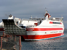
Day 4 was Orkney Day! Our early morning alarm call galvanised us into action and we were soon heading the 40 plus miles northwards to Gills Bay to catch our 9.30 am ferry - the Pentalina. Our enthusiam to reach our destination without delay gave us time to spare, so we stopped off at John O'Groats in the hope of a quick coffee - sadly there was no hope, no coffee, no human life to be seen, only Eric the Viking. But nothing would dent our enthusiasm as we drove the few short miles westwards to Gills Bay. And as we rounded the harbour wall the sun came out to make things perfect!
Our departure point had not been our first choice, but had instead been decided for us. On checking the ferry sailing times we had been dismayed to find that passports were needed for identification purposes - and ours had purposely been left behind along with the decision to drive rather than fly to Scotland! Thankfully Pentland Ferries was the only company sailing to Orkney which didn't insist on this, and we couldn't have been more relieved and happy with their decision to exclude this condition. Gills Bay might not have been the prettiest harbour, but it was fit for purpose, and enabled us to get on our way ... in a fair amount of style too, as the ferry turned out to be a smart, impressive Catamaran. With more containers on board than passengers, our trip across the Pentland Firth was calm, peaceful and quite sunny ... past the Islands of Stroma, Swona, Hoy, Flotta and South Ronaldsay, into Scapa Flow, where we were deposited at St Margarets Hope ready to start our exploration of these purportedly beautiful islands. We were not to be disappointed.
Our aim was to see as much of the largest island as was possible in a day, and we had ear-marked several 'must sees' on the west coast. But even the drive to the 'West Mainland' was an adventure, as we 'island-hopped' across the famous 'Churchill Barriers' between South Ronaldsay and Burray, across to Glimps Holm, and Lamb Holm, then East Mainland and finally onto West Mainland. The Churchill Barriers were built in WW2 in response to the sinking of HMS Royal Oak by U47, which entered Scapa Flow via Holm Sound. 883 crew were killed, and within a month Winston Churchill visited Orkney and ordered that work should commence on the construction of 4 permanent 'defence' barriers linking together the chain of islands. Ironically they were completed just in time for the war's end, but 550 Italian prisoners of war who worked on the project have instead left a transport network legacy for Orcadians and visitors alike. Across the first such barrier we stopped at a unwitting but fitting tribute to the POW's - a charming Italian Chapel, which they had converted from 2 Nissen huts into a unique place of worship and a stunning representation of Italian Rennaisance art, complete with a gilded frescoed vault.
As we snaked our way between and across the islands, past the tragic and eerie half sunk warships and scenes of naval embarrassment from 1939, the magic of Orkney started to shine through. It might have been the luminous light; the low lying sparsely populated islands; the intensity of green fields against a mauve-blue sky; the sense of complete distance and remoteness from mainland UK; the remnants of ancient Neolithic/Viking/Celtic history, or maybe a combination of them all. Whatever it is that gives these islands their unique quality was in evidence that day, and will remain with me.
The main highlight of the day was Skara Brae. One of the earliest examples of a 'village' or community of individual dwellings, incredibly 5000 years old, unearthed by a storm in 1850 to reveal the most perfectly preserved site of its kind in Northern Europe. The fact that it overlooks what must be one of the most remote and stunning white curved beaches in the UK only adds to the mystique and mystery of this very special heritage site. The Bay of Skaill and its revelations need to be experienced to be believed. With dressers, beds, lintels, cupboards, rooms, doorways and corridors all still intact, Skara Brae has opened up many of its secrets, but tantalisingly hasn't revealed any tangible evidence to suggest why its inhabitants abandoned their innovative community and way of life. We too had to abandon this magical place to continue our exploration around the coast, with what little time we had left on Orkney.
From the magic and mystery of Skara Brae to the mystical and iconic setting of the Ring o'Brodgar. As if deliberately hidden from the view of passing travellers, we eventually found this prehistoric monument in the centre of a massive natural 'cauldron' formed by the hills of the surrounding landscape. Built somewhere between 2500 and 2000 BC this Neolithic stone circle is 104 metres wide and is the 3rd largest in the British Isles. Thought to have originally contained 60 megaliths, only 27 remain today. To see this remarkable site in the equally remarkable setting of Orkney and with the sun setting in the late Spring sky was yet another memory that will stay with me. And so, loathe as we were to leave this awesome archipelago, we headed off back to catch our ferry and to return to Kirkton Cottage, our Highland home for just 2 more days.
After our full day in the Orkneys we decided to spend Day 5 locally, in our 'own' Strath Kildonan. The weather was dry, if not bright and sunny, but we were hoping to strike gold regardless! Back in 1818 a gold nugget was found in the Helmsdale river, and some some 50 years later Helmsdale had its own goldrush! Just a few miles up the valley from Kirkton Cottage, legend has it that £12000 of gold was found in the hills around what is now called Baile an Or. As is often the case where money is concerned, greed and conflict eventually ended the gold rush, when the Duke of Sutherland found he was losing more potential income from the 'sheep, fishing & shooting fraternity' than he was gaining from the gold prospectors. 100 years on, this didn't prevent 2 tourists from scanning the river for glittering nuggets! Our walk along Suisgill Valley followed the course of the twisting and babbling Burn. The path initially hugged the waters edge but in places we were forced upwards by steeply and deeply thicketed banking, which gave us alternative but amazing views down and across the valley. Five or six miles later, after aborting our searching for gold, and a route across the river that didn't involve getting wet feet, we headed back to the car, empty handed but with dry feet. And whilst we hadn't found gold, we had enjoyed a peaceful walk in a perfectly natural landscape, home to wild red deer and Felix. Felix was the tiny, colourful but frightened frog on our path who covered his head with his paws to protect himself from being trodden on - my precious little nugget of dark green and gold.
After a picnic lunch we decided to venture across the valley and venture down a single track road we'd passed a few times, to see where it lead us. We were so glad we did! After crossing the little bridge which spanned the Helmsdale river, the narrow road wound onwards and upwards out of the valley. We stopped on the road side when a wide expanse landscape photo opportunity offered itself, and noticed a familiar looking 'spec' on the far side of the valley ... it was Kirkton Cottage, looking more beautiful and remote than we had seen it before (see photo). Moving onwards and upwards once more, we still hadn't passed a single car and the only signs of life around were deer and sheep. The road turned and levelled, and as it did so we found ourselves in the next valley, and facing another jaw-dropping view. This was Glen Loth. A huge, remote landscape enclosed on all sides by mountains and with just one narrow grass-covered track through it. As we descended into the valley we passed the remains and ruins of a previous community, and the standing standing stones of an even earlier one. We drove through the valley in complete silence, overawed by the incredible raw beauty and sense of complete isolation. No people, cars, buildings or indications that people had ever driven through Glen Loth - even the road was slowly being reclaimed by the land, with clumps of grass and weeds drifting, rooting and sprouting into life from adjacent land into the cracks and potholes. For the first time in my life I could imagine how a time traveller might feel being transported back 100 years ... . Some 12 miles on we emerged somewhat unexpectedly on the A9 coast road, back to cars, people, civilisation, 2010 ... and frogs!
On the last leg of our journey back to the cottage we noticed the road was littered with mud, or something. Then a few pieces of mud hopped, and we realised that a whole army of frogs was in the process of crossing the road to get to the river. Not just in one place, but along the 5 mile remaining stretch of road leading to Kirkton Cottage! Avoiding every one of the 1000s of frogs doing their 'green cross code hop' was impossible, but we steered our way slowly and cautiously along the road, meeting more 'life' in 15 minutes than we had encountered in the whole of our week to that point!
Day 6 had a false start, or to be more accurate, a leaky start. We had planned to explore the North Coast as far west as possible, given the mileage and time constraints. A very nice man in a backstreet Helmsdale garage checked the car over and tentatively gave us the thumbs up to proceed with our day. So we tentatively jumped back in the car and tentatively drove north with one eye on the road and three on the water temperature gauge! Our first stop was Dunnet Bay. We'd ended Day 2 at Dunnet Head, as the sun was sinking in the sky behind the most Northerly point on mainland UK. This was an opportunity to enjoy the 2 mile wide curved expanse of white sandy beach, and a picnic! With the exception of a woman and her dog we had the whole bay to ourselves, with watery views stretching across the Pentland Firth to distant Iceland, Greenland and beyond. Sadly the views became even more watery as the rain fell and stopped picnic plans! So we jumped back in the car and headed for Strathy Point, yet another of the strategic lighthouse sites along this craggy and dangerous coastline. But on this day it looked craggy and friendly, lit by blue sky and sun, giving us lots of photo opportunities!
Continuing westward across the 'top of mainland UK' we arrived at the charmingly named 'Bettyhill'. The bay was equally appealing. A pretty, peaceful and remote bay, entirely natural, with no trappings of tourism. An innocently cute name for a place re-named by the person responsible for the 'Highland Clearances' of 15000 people off Betty Sutherland's heavily populated estate between 1811 and 1821. Betty, aka the Countess of Sutherland, took unusual steps to build a replacement village near the coast, and Bettyhill is a legacy of those times. Wealthy landowners (Duke & Duchess of Sutherland) had brutally dispossessed tenant farmers of their land to use it for extensive and more lucrative sheep farming. Thousands of peasant farmers fled from their homes, and when faced with famine had no option but to emigrate. We had no option but to continue to our last stop of the day, which was also the most westerly point of our holiday, the Kyle of Tongue.
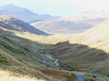
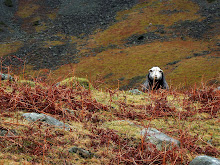
After 50 miles of driving, Ben Loyal was a sight for sore eyes (see photo). We drove down to the Kyle (Channel) and reflected on Scottish history once more before wending our way 'home'. In 1746 the ship 'Hazard' carrying £13K in gold coins to fund Bonnie Prince Charlie's rebellion fled into the Kyle of Tongue to evade HMS Sheerness ... and the gold was thrown into the Loch by the crew before they were captured. Most of the gold was recaptured by the government, so we didn't hang around waiting for the tide wash up our fortune. Instead we continued on our way down Strath Naver to Kildonan - a particularly scenic route made all the more majestic by a group of red deer who were quite clearly the landowners (see photo).
Day 7 had arrived, the final day of our holiday. We wanted to adopt more leisurely pace on the day before our epic journey home, so decided to check out our local town Helmsdale and the surrounding area. Helmsdale is probably best known for its bridges, and these span the mouth of the River Helmsdale which flows up the valley (Strath Kildonan) to Kirkton Cottage. The prettiest by far is down to the handiwork of Thomas Telford, built in 1811. Until recently this bridge formed part of the main A9 road north, but has thankfully been replaced further downstream to protect it from the heavy traffic flows. At the mouth of the river is an imposing statue - known as Helmsdale's retaliation to the Duke of Sutherland's 100' tall statue in Golspie further down the coast. 'The Emigrants' statue depicts and commemorates the achievement of thousands of Scots who left the Highlands during the Clearances of the 19th century. A clever and touching memorial to the Emigrants, built in stark, and cleverly understated contrast to the overstated, oversized glorification of wealth & land ownership just a few miles to the south.
Having battled with high winds on the cliff top, we decided to take a walk at sea level up the coast from Helmsdale, a route we had only driven to date. When we reached the pretty little harbour, it became clear the wind was equally strong at ground level! Barely able to stand upright, we fought against strong gusts until we reached the relative calm of a pretty stretch of coastline. We followed the beach from bay to bay, bright blue skies above us and beaches brimming with pretty stones and shells below us .. and all the while not a soul in sight, just nature and Helmsdale at its very best.
Our unplanned, unanticipated but truly memorable coastline walk was a perfect 'last activity' for the week. It ended in Strath Ullie Crafts Shop, a delightful Aladdin's Cave of unique and very reasonably priced local crafts, where we had difficulty in restricting our purchases to just a few mementoes of our time in the Highlands! The day ended in style with fish and chips from the local (but TV renowned) chippie in Helmsdale, and was a fitting end to what had been a fascinating insight into area of the UK that neither of us knew or had any pre-conceptions about. It will be remembered for many things, but especially The Orkneys and Strath Kildonan, our base for the week and one of the most stunning locations we have stayed in. The Highlands score very highly in our holiday ratings!


No comments:
Post a Comment