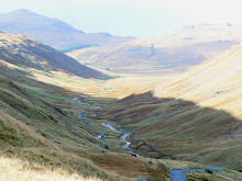
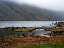
Tucked away on the west side of Cumbria in the Wasdale Valley, and cut off from the rest of Lakeland by its mountains, Wast Water and it's valley are little changed by human habitation or tourism. I was inspired by this place. Apparently Wainwright was too. He wrote, "one of the loveliest of Lakeland's valleys, descends from the highest and wildest mountains in the district to the sands of Ravenglass in a swift transition from grandeur to beauty ... it is a place of many delights, the finest of all valleys for those whose special joy is to travel on foot, and a paradise for artists." In sharp contrast Wordsworth rather harshly described it as 'long stern and desolate', it's true the fells can appear dark and foreboding, but then again, it has recently been winner of a TV vote to find 'Britain's Finest View'! Clearly it can't be all things to all people, but that's fine by me if it means that Wast Water remains unadulterated and uncluttered by people.
When it comes to extremes, this western region of the Lake District is purportedly home to England's deepest, coldest, highest, steepest, smallest and oldest! Scafell Pike at 978m being England's highest mountain, Wast Water at 258 feet it's deepest and coldest lake, Hardknott Pass it's steepest road, St Olaf's Church it's smallest church and Boot Mill, it's oldest working water mill.
When it comes to statistics, Wast Water is approximately 3 miles long and a third of a mile wide, and it's picturesquely hemmed in by a panorama of majestic mountains, Red Pike (802m), Kirk Fell (438m), Whin Rigg (535m), Illgill Head (609m), Great Gable (899m) and Scafell Pike (978m).
It's also one of the finest examples of a glacially 'over-deepened' valley - the surface of the lake is about 200m above sea level, while it's bottom is over 50 feet below sea level. And falling dramatically into this deep lake from a height of 610m above the surface to a depth of 61m below it are 'The Wast Water Screes'. These dramatic and foreboding sliding scree-covered slopes were formed as a result of freeze/thaw weathering erosion on the rocks that cascade down from the slopes of Illgill Head and Whin Rigg. Poetically, these have been described as 'inverted arches of Gothic cathedral'. Ecologically, they form part of the Borrowdale Volcanic Group, and are typical in formation for the south western area of the Lake District.
We didn't know all that stuff before we went, of course. I wanted to see Wast Water purely because it was recommended to me as being one of the quietest, most well hidden lakes, surrounded by some dramatic high peaks and in an area with few access roads, none of which are wide or flat. Perfect!
On the day we visited Wast Water the clouds had descended into the Wasdale Valley hiding the peaks, but revealing the awesome atmosphere of this place. A narrow road lead us around the lake's north shore leading to the valley head and to the tiny hamlet of Wasdale Head, and it was here that our walk began.
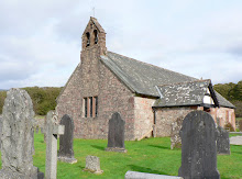
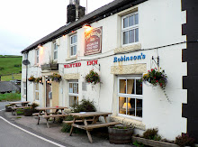
Leaving the pretty white Wasdale Valley Hotel behind us, and the imposing 'upturned-boat shaped' Yewbarrow Fell (628m) behind that, we followed the waymarked trail across the valley eastwards. With views of Scafell Pike ahead, we continued our low level walk along the path and over Lingmell Beck until we came to a tiny church nestling in the valley behind a screen of trees. We later learned that St Olaf's Church is one of the smallest in the country, and alledgedly, it's roof beams have come from Viking ships, which is feasible, given that this valley was indeed colonised by Norse farmers in the 9th and 10th century. We didn't venture inside however, as the scenery outside had a stronger attraction.
The next mile or two of the footpath was bordered by one of the many dry stoned walls that cross-cut Wasdale Valley, some forming sheep pens, others forming hump-backed bridges over the beck and many of them following the contours of the lower fell. But collectively they added focus, foreground and photographic value to this already pretty valley.
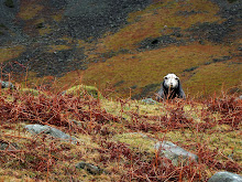
On reaching the foot of Kirk Fell, we stopped to have a quick bleat with 'Walter of Wasdale' who was busy grazing on bracken and gazing through the mist on it's slopes. Walter and his woolly mates were a bit bemused by our interest in them, but obliged us with some photos and a few baas nevertheless.


No comments:
Post a Comment